Skeda:Ancient Epirus & Modern Borders (Colored).svg

Size of this PNG preview of this SVG file: 411 × 599 pixel. Rezolucione të tjera: 165 × 240 pixel | 329 × 480 pixel | 527 × 768 pixel | 703 × 1.024 pixel | 1.406 × 2.048 pixel | 688 × 1.002 pixel.
Dokument origjinal (skedë SVG, fillimisht 688 × 1.002 pixel, madhësia e skedës: 175 KB)
| Kjo skedë është prej Wikimedia Commons dhe mund të përdoret nga projekte të tjera. Përshkrimi në këtë skedë në këtë faqe nuk është treguar më poshtë. | Shko tek faqja përshkruese në Commons |
.svg)
Përmbledhje
| Përshkrimi |
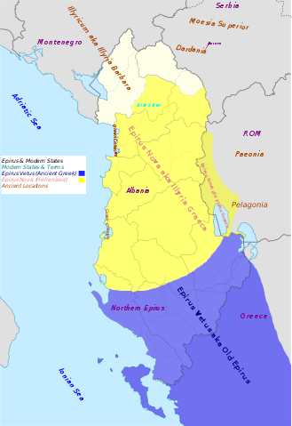
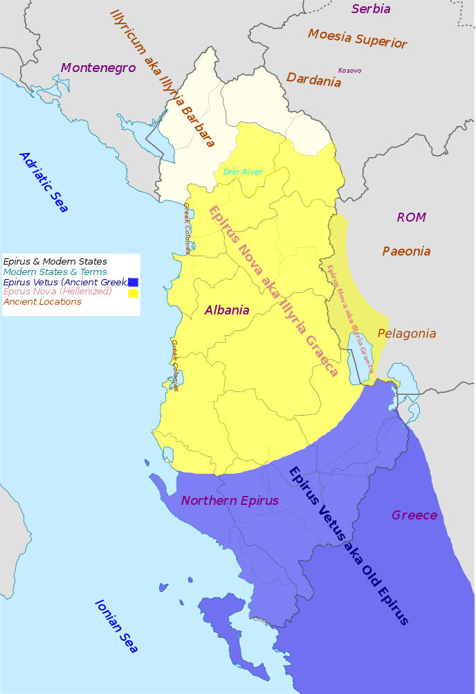
English: Map of "The Ancient Greek region of Epirus and the Situation today".Approximate extent of Ancient Epirus,Epirus Vetus,Epirus Nova (Illyria Graeca) and adjoining Provinces and regions. The expansion of the Greek region of Epirus into Illyria. Anachronistic. |
| Data | |
| Burimi | Punë e juaja |
| Autori | MaryroseB54 |
| Versione tjera |
 |
- American journal of philology, Τόμοι 98-99,by JSTOR (Organization), Project Muse,1977,page 263, the partly Hellenic and partly Hellenized Epirus Nova
- Epirus Vetus: The Archaeology of a Late Antique Province (Duckworth Archaeology) by William Bowden,2003,ISBN-10: 0715631160,2003,page 233,of Lissos in Epirus Nova
- Migrations and invasions in Greece and adjacent areas by Nicholas Geoffrey Lemprière Hammond,1976,ISBN -0815550472,page 54,The line of division between Illyricum and the Greek area Epirus nova
- Hammond, N. G. L. A History of Greece to 322 B.C., 1986, ISBN-10: 0198730950
- Triadafilopoulos, Triadafilos (November 2000). "Power politics and nationalist discourse in the struggle for 'Northern Epirus': 1919-1921". Journal of Southern Europe and the Balkans,
- Encyclopedia Britannica,2002,ISBN -0852297874,The Roman province of Illyricum stretched from the Drilon River (the Drin, in modern Albania) in the south to Istria (modem Slovenia and Croatia)
- The Illyrians (The Peoples of Europe) by John Wilkes,1996,ISBN-9780631198079,Wilkes gives the limites of Epirus Nova at Drilon river
- The Illyrians (The Peoples of Europe) by John Wilkes,1996,ISBN-9780631198079,page 208
- History of the Byzantine Empire: Vol. 1, 324-1453 (Paperback) by Alexander A. Vasiliev
- File:Albania_location_map.svg
Licencim
Unë, krijuesi i kësaj pune, e publikoj këtu në bazë të licensës në vijim:
This file is licensed under the Creative Commons Attribution-Share Alike 4.0 International license.
- Je i lirë të:
- ta shpërndani – ta kopjoni, rishpërndani dhe përcillni punën
- t’i bëni “remix” – të përshtatni punën
- Sipas kushteve të mëposhtme:
- atribuim – Duhet t’i jepni meritat e duhura, të siguroni një lidhje për tek licenca dhe të tregoni nëse janë bërë ndryshime. Këtë mund ta bëni në ndonjë mënyrë të arsyeshme, por jo në ndonjë mënyrë që sugjeron se licencuesi ju del zot juve apo përdorimit tuaj.
- share alike – Nëse bëni një “remix”, e shndërroni, ose ndërtoni duke u bazuar te materiali, duhet t’i shpërndani kontributet tuaja sipas të njëjtës licencë ose një të tille të përputhshme me origjinalen.
Historiku skedës
Shtypni mbi një datë/kohë për ta parë skedën siç ishte atëherë.
| Data/Koha | Miniaturë | Përmasat | Përdoruesi | Koment | |
|---|---|---|---|---|---|
| e tanishme | 3 korrik 2016 11:44 | | 688 × 1.002 (175 KB) | MaryroseB54 | User created page with UploadWizard |
Lidhje skedash
Këto faqe lidhen tek kjo skedë:
Përdorimi global i skedës
Kjo skedë përdoret nga Wiki të tjera në vijim:
- Përdorimi në cs.wikipedia.org
- Përdorimi në el.wikipedia.org
- Përdorimi në en.wikipedia.org
- Përdorimi në es.wikipedia.org
- Përdorimi në et.wikipedia.org
- Përdorimi në fr.wikipedia.org
- Përdorimi në gl.wikipedia.org
- Përdorimi në it.wikipedia.org
- Përdorimi në lt.wikipedia.org
- Përdorimi në mk.wikipedia.org
- Përdorimi në nl.wikipedia.org
- Përdorimi në sk.wikipedia.org
- Përdorimi në sl.wikipedia.org
.svg)