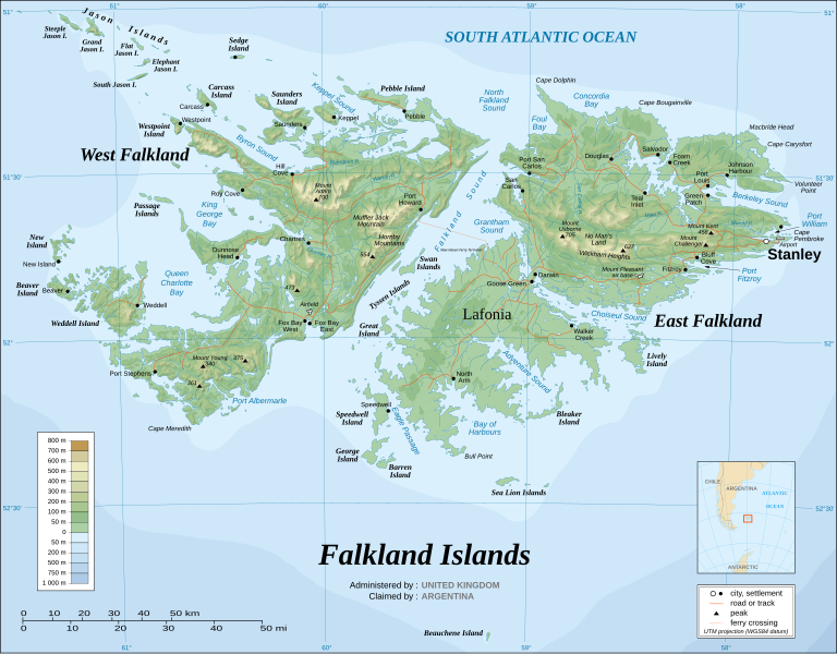
Dokument origjinal(skedë SVG, fillimisht 2.550 × 1.990 pixel, madhësia e skedës: 1,97 MB)

Kjo skedë është prej Wikimedia Commons dhe mund të përdoret nga projekte të tjera. Përshkrimi në këtë skedë në këtë faqe nuk është treguar më poshtë. Shko tek faqja përshkruese në Commons Shko tek faqja përshkruese në Commons

 
  This SVG map uses required raster graphics to show delicate structures.
Imazh of the year
Imazh of the year
Featured imazh

Wikimedia CommonsWikipedia

This file was a candidate in Picture of the Year 2007.
This is a featured picture on Wikimedia Commons (Fotografi të Shkëlqyeshme) and is considered one of the finest images. See its nomination here.

 This is a featured picture on the English language Wikipedia (Featured pictures) and is considered one of the finest images. See its nomination here.

If you have an image of similar quality that can be published under a suitable copyright license, be sure to upload it, tag it, and nominate it.


Pour agrandir l'image

Detailed map of large dimension. For a better viewing, click on the link of the image above.
Carte détaillée de grande dimension. Pour une visualisation optimale, cliquer sur le lien de l'image ci-dessus.

Përmbledhje

Përshkrimi
English: The Falkland Islands are an archipelago in the South Atlantic Ocean, located 300 miles off the coast of Argentina. They consist of two main islands, East Falkland and West Falkland, together with about 700 smaller islands. Stanley, on East Falkland, is the capital and largest city. The islands are a self-governing Overseas Territory of the United Kingdom.
Français : Carte topographique en anglais des Îles Malouines. Les Malouines forment un archipel dans l'Océan Atlantique Sud à 480 km des côtes argentines. Il est composé de deux îles principales, East Falkland et West Falkland, et de 700 autres îles et îlots. Stanley, sur East Falkland, est la capitale et la plus grande agglomération de l'archipel. Les Malouines sont un territoire autonome du Royaume-Uni.
Nederlands: Topografische kaart van de Falklandeilanden, een Brits overzees gebiedsdeel in de Zuidelijke Atlantische Oceaan. De archipel bestaat uit twee hoofdeilanden en ongeveer 700 kleinere op ongeveer 300 kilometer uit de kust van Argentinië. Stanley op het eiland 'East Falkland' is de hoofdstad en tergelijkertijd de meest bevolkte gemeente van het eilandengroep.De eilanden zijn een 'self-governing Overseas Territory' van het Verenigd Koninkrijk van Groot-Brittannië en Noord-Ierland.
Português: Mapa topográfico (em inglês) das Ilhas Malvinas, um arquipélago no sul do Oceano Atlântico, a 300 milhas da costa da Argentina. Consiste de duas ilhas, Soledad a leste e Gran Malvina, a oeste, junto com cerca de 700 outras ilhotas. A capital (e maior cidade) é Stanley. As Malvinas são um território autónomo do Reino Unido.
SVG genesis
InfoField
 
The SVG code is valid.
 
This map was created with Inkscape.
{| cellspacing="8" cellpadding="0" style="clear:both; width:100%; margin:0.5em auto; border:2px solid #88A; background-color:#F7F8FF;" lang="sq" dir="ltr"

|align="center"|Translate this file

|width="100%"|

Kjo skedë SVG përdor tekst i cili mund të përkthehet fare lehtë në gjuhën tënde përmes [toolforge:svgtranslate/File:Falkland_Islands_topographic_map-en.svglink këtij mjeti] në mënyrë automatike. Lexo më tepër. Gjithashtu ju mund ta shkarkoni këtë skedar dhe ta redaktoni manualisht përmes një tekst-editori.

|}
Data November 2007 using elements from the original version of April 2007
Burimi Own work ;
Topographic map : NASA Shuttle Radar Topography Mission (SRTM3 v.2) (public domain) edited with dlgv32 Pro/Global Mapper and vectorized with Inkscape ; UTM projection ; WGS84 datum ; shaded relief (composite image of N-W, W and N lightning positions) ;
Approximate scale of topographic data and shore / lakes limits : 1:705,000 ; of the bathymetry : 1:3.720.000
Bathymetry : USGov public domain data provided by the Demis add-on for World Wind (see the approval e-mail) ;
Other references used for additional data :
* UK government map ;
* NASA World Wind ;
* CIA map available on the site of the University of Texas at Austin ;
* Microsoft Encarta atlas (1999 edition).
Note : The shaded relief is a raster image embedded in the SVG file which increases its size. If you want a lighter map for other purposes, delete the shaded relief image in your file.
Krijues
Eric Gaba (Sting - fr:Sting)
Leja
(Ripërdor këtë skedë)
Attribution and Share-Alike required
Georeferencing Georeference the map in Wikimaps Warper If inappropriate please set warp_status = skip to hide.
Versione tjera

Derivative works of this file:

[redakto]


Licencim

Unë, krijuesi i kësaj pune, e publikoj këtu në bazë të licensës në vijim:
GNU head Ju jepet leje për ta kopjuar, shpërndarë dhe/ose ndryshuar këtë dokument sipas kushteve të Licencës GNU për Dokumentim të Lirë, versioni 1.2 ose çfarëdo versioni të mëpasshëm të botuar nga Free Software Foundation; pa Seksione të Pandryshueshme, pa Tekste Kapakësh të Përparmë, dhe pa Tekste Kapakësh të Pasmë. Një kopje e kësaj licence është përfshirë në seksionin e titulluar GNU Free Documentation License.
w:sq:Creative Commons
atribuim share alike
Kjo skedë licencohet sipas Creative Commons Attribution-Share Alike 3.0 Unported.
Je i lirë të:
  • ta shpërndani – ta kopjoni, rishpërndani dhe përcillni punën
  • t’i bëni “remix” – të përshtatni punën
Sipas kushteve të mëposhtme:
  • atribuim – Duhet t’i jepni meritat e duhura, të siguroni një lidhje për tek licenca dhe të tregoni nëse janë bërë ndryshime. Këtë mund ta bëni në ndonjë mënyrë të arsyeshme, por jo në ndonjë mënyrë që sugjeron se licencuesi ju del zot juve apo përdorimit tuaj.
  • share alike – Nëse bëni një “remix”, e shndërroni, ose ndërtoni duke u bazuar te materiali, duhet t’i shpërndani kontributet tuaja sipas të njëjtës licencë ose një të tille të përputhshme me origjinalen.
Kjo etiketë licencimi u shtua te kjo skedë si pjesë e përditësimit të lincecimit. GFDL.
w:sq:Creative Commons
atribuim share alike
Kjo skedë është dhënë për përdorim sipas licensës Creative Commons Attribution-Share Alike 2.5 Generic, 2.0 Generic dhe 1.0 Generic.
Je i lirë të:
  • ta shpërndani – ta kopjoni, rishpërndani dhe përcillni punën
  • t’i bëni “remix” – të përshtatni punën
Sipas kushteve të mëposhtme:
  • atribuim – Duhet t’i jepni meritat e duhura, të siguroni një lidhje për tek licenca dhe të tregoni nëse janë bërë ndryshime. Këtë mund ta bëni në ndonjë mënyrë të arsyeshme, por jo në ndonjë mënyrë që sugjeron se licencuesi ju del zot juve apo përdorimit tuaj.
  • share alike – Nëse bëni një “remix”, e shndërroni, ose ndërtoni duke u bazuar te materiali, duhet t’i shpërndani kontributet tuaja sipas të njëjtës licencë ose një të tille të përputhshme me origjinalen.
Mundeni të përzgjidhni licencën që doni.

Captions

Add a one-line explanation of what this file represents

Items portrayed in this file

përshkruan

topographic map anglisht

image/svg+xml

Historiku skedës

Shtypni mbi një datë/kohë për ta parë skedën siç ishte atëherë.

(më të rinj | më të vjetër) Shikoni (10 më të reja) () (10 | 20 | 50 | 100 | 250 | 500).
Data/KohaMiniaturëPërmasatPërdoruesiKoment
e tanishme23 gusht 2021 04:51Miniaturë për versionin duke filluar nga 23 gusht 2021 04:512.550 × 1.990 (1,97 MB)Praça de MaioFile uploaded using svgtranslate tool (https://svgtranslate.toolforge.org/). Added translation for tr.
23 gusht 2021 04:50Miniaturë për versionin duke filluar nga 23 gusht 2021 04:502.550 × 1.990 (1,97 MB)Praça de MaioFile uploaded using svgtranslate tool (https://svgtranslate.toolforge.org/). Added translation for tr.
6 prill 2017 13:54Miniaturë për versionin duke filluar nga 6 prill 2017 13:542.550 × 1.990 (1,91 MB)RaviC+ New Haven Ferry
19 dhjetor 2008 20:38Miniaturë për versionin duke filluar nga 19 dhjetor 2008 20:382.550 × 1.990 (1,93 MB)StingReverted to version as of 03:38, 14 November 2007: please upload the translated version under a specific name
19 dhjetor 2008 20:26Miniaturë për versionin duke filluar nga 19 dhjetor 2008 20:262.550 × 1.990 (1,93 MB)Vitekthis is just croatian translation
14 nëntor 2007 05:38Miniaturë për versionin duke filluar nga 14 nëntor 2007 05:382.550 × 1.990 (1,93 MB)StingNew version more accurate and with shaded relief
16 qershor 2007 03:18Miniaturë për versionin duke filluar nga 16 qershor 2007 03:182.550 × 1.990 (1,03 MB)StingReverted to earlier revision
16 qershor 2007 03:03Miniaturë për versionin duke filluar nga 16 qershor 2007 03:032.550 × 1.990 (2,14 MB)StingTrying to fix the bug on WP-en #8
16 qershor 2007 02:40Miniaturë për versionin duke filluar nga 16 qershor 2007 02:402.550 × 1.990 (2,01 MB)StingTrying to fix the bug on WP-en #7 (really boring...)
16 qershor 2007 02:29Miniaturë për versionin duke filluar nga 16 qershor 2007 02:292.550 × 1.990 (2,08 MB)StingTrying to fix the bug on WP-en #6 (OK, the problem comes from the shaded relief raster image)
(më të rinj | më të vjetër) Shikoni (10 më të reja) () (10 | 20 | 50 | 100 | 250 | 500).

Këto faqe lidhen tek kjo skedë:

Përdorimi global i skedës

Kjo skedë përdoret nga Wiki të tjera në vijim:

Shikoni më shumë përdorim global të kësaj skede.

Metadata