Dokument origjinal(skedë SVG, fillimisht 6.436 × 6.253 pixel, madhësia e skedës: 172 KB)

Kjo skedë është prej Wikimedia Commons dhe mund të përdoret nga projekte të tjera. Përshkrimi në këtë skedë në këtë faqe nuk është treguar më poshtë. Shko tek faqja përshkruese në Commons Shko tek faqja përshkruese në Commons

Përmbledhje

Përshkrimi
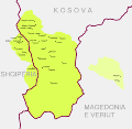
Shqip: Krahina e Gorës
English: Gora region
  • Map of Gorani settlements and Gora region (green) and adjacent area in the Polog region (yellow) that is culturally and linguistically associated with the core region.


Gorani inhabited settlements in Albania and Kosovo are synonymous with the geographical outline of Gora as a region. (see: Bardhoshi, Nebi (2016) "Small Numbers, Big issues: The Border areas as Social Arena of Legal Systems" in Exchange, Dialogue, New Divisions?: Ethnic Groups and Political Cultures in Eastern Europe, LIT Verlag, p. 83. ISBN: 9783643802095. )

  • Albania:

Steinke, Klaus (2010) Die slavischen Minderheiten in Albanien (SMA). 3. Gora, Mynihu: Verlag Otto Sagner, p. 11. ISBN: 978-3-86688-112-9.

Schmidinger, Thomas (2013). Gora: Slawischsprachige Muslime zwischen Kosovo, Albanien, Mazedonien und Diaspora. Wiener Verlag. pp. 98-99. ISBN 9783944690049

  • Kosovo:

Schmidinger, Thomas (2013). Gora: Slawischsprachige Muslime zwischen Kosovo, Albanien, Mazedonien und Diaspora. Wiener Verlag. p. 65. ISBN 9783944690049

Schmidinger, Thomas (2018) "Forced return to empty villages: A case study of the Gorani in Kosovo" in Remigration to Post-Socialist Europe. Hopes and Realities of Return, Lit Verlag, p. 265. ISBN: 9783643910257.

  • North Macedonia (2 villages in the Polog region):

Koleva, Krasimira (2012) "Balkanisms today: The dialect of Župa (Kosovo)" in Balkanismen heute – Balkanisms today – Балканизмы сегодня, LIT Verlag, p. 351. ISBN: 9783643503886.

Rexhepi, Besnik; Mustafa, Behxhet; Hajdari, Avni; Rushidi-Rexhepi, Jehona; Quave, Cassandra L.; Pieroni, Andrea (2014). "Cross-cultural ethnobotany of the Sharr Mountains (northwestern Macedonia)". In Pieroni, Andrea; Quave, Cassandra L. (eds.). Ethnobotany and Biocultural Diversities in the Balkans. Springer. p. 70. ISBN 9781493914920


The boundaries of the region and its settlements shown in the map are based on the cadastral record. The following government based sources were used for the composition of the map.

  • Albania: Kukës County (map of Shishtavec unit [1]; map of Zapod unit [2])
  • Kosovo: Dragash Municipality covered in cadastral map [3]
  • North Macedonia: Bogovinje Municipality covered in cadastral map [4]
Data
Burimi Punë e juaja
Autori Resnjari

Licencim

Unë, krijuesi i kësaj pune, e publikoj këtu në bazë të licensës në vijim:
w:sq:Creative Commons
atribuim share alike
This file is licensed under the Creative Commons Attribution-Share Alike 4.0 International license.
Je i lirë të:
  • ta shpërndani – ta kopjoni, rishpërndani dhe përcillni punën
  • t’i bëni “remix” – të përshtatni punën
Sipas kushteve të mëposhtme:
  • atribuim – Duhet t’i jepni meritat e duhura, të siguroni një lidhje për tek licenca dhe të tregoni nëse janë bërë ndryshime. Këtë mund ta bëni në ndonjë mënyrë të arsyeshme, por jo në ndonjë mënyrë që sugjeron se licencuesi ju del zot juve apo përdorimit tuaj.
  • share alike – Nëse bëni një “remix”, e shndërroni, ose ndërtoni duke u bazuar te materiali, duhet t’i shpërndani kontributet tuaja sipas të njëjtës licencë ose një të tille të përputhshme me origjinalen.

Captions

Add a one-line explanation of what this file represents

Items portrayed in this file

përshkruan

7 shtator 2020

Historiku skedës

Shtypni mbi një datë/kohë për ta parë skedën siç ishte atëherë.

Data/KohaMiniaturëPërmasatPërdoruesiKoment
e tanishme7 shtator 2020 12:57Miniaturë për versionin duke filluar nga 7 shtator 2020 12:576.436 × 6.253 (172 KB)ResnjariUploaded own work with UploadWizard

Këto faqe lidhen tek kjo skedë:

Përdorimi global i skedës

Kjo skedë përdoret nga Wiki të tjera në vijim:

Metadata