Skeda:Polutok Klek i granica.JPG
Nuk ka përmasa më të madhaja.
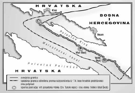
Polutok_Klek_i_granica.JPG ((përmasa 434 × 300 px, madhësia skedës: 32 KB, lloji MIME: image/jpeg))
| Kjo skedë është prej Wikimedia Commons dhe mund të përdoret nga projekte të tjera. Përshkrimi në këtë skedë në këtë faqe nuk është treguar më poshtë. | Shko tek faqja përshkruese në Commons |
| Përshkrimi |
Hrvatski: Poluotok Klek i granica R. Hrvatske i BiH English: Klek peninsula and boarder between Republic of Croatia and Bosnia and Herzegovina |
||
| Data | |||
| Burimi | http://upload.wikimedia.org/wikipedia/bs/3/3f/Bosansko_poluostrvo_Klek.jpg | ||
| Autori | archy | ||
| Leja (Ripërdor këtë skedë) |
|

|
Kjo map fotografi duhet duhen te behen edhe i here si nje SVG.
|


Historiku skedës
Shtypni mbi një datë/kohë për ta parë skedën siç ishte atëherë.
| Data/Koha | Miniaturë | Përmasat | Përdoruesi | Koment | |
|---|---|---|---|---|---|
| e tanishme | 17 tetor 2012 10:02 | | 434 × 300 (32 KB) | Quahadi | {{Information |Description=Poluotok Klek i granica R. Hrvatske i BiH Klek peninsula and boarder between Republic of Croatia and Bosnia and Herzegovina |Source=http://upload.wikimedia.org/wikipedia/bs/3/3f/Bosansko_poluostrvo_Klek.jpg |Date= 2008-07-11... |
Lidhje skedash
Këto faqe lidhen tek kjo skedë:
Përdorimi global i skedës
Kjo skedë përdoret nga Wiki të tjera në vijim:
- Përdorimi në ar.wikipedia.org
- Përdorimi në bs.wikipedia.org
- Përdorimi në de.wikipedia.org
- Përdorimi në en.wikipedia.org
- Përdorimi në es.wikipedia.org
- Përdorimi në hu.wikipedia.org
- Përdorimi në it.wikipedia.org
- Përdorimi në ja.wikipedia.org
- Përdorimi në mk.wikipedia.org
- Përdorimi në sl.wikipedia.org