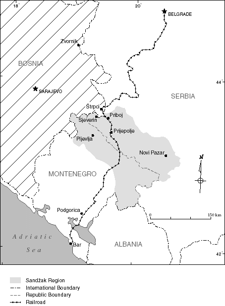
Skeda:Sandzak region map-sr.png

Madhësia e këtij shikimi: 628 × 600 pixel. Rezolucione të tjera: 251 × 240 pixel | 503 × 480 pixel | 974 × 930 pixel.
Dokument origjinal ((përmasa 974 × 930 px, madhësia skedës: 53 KB, lloji MIME: image/png))
| Kjo skedë është prej Wikimedia Commons dhe mund të përdoret nga projekte të tjera. Përshkrimi në këtë skedë në këtë faqe nuk është treguar më poshtë. | Shko tek faqja përshkruese në Commons |
Përmbledhje
| Përshkrimi |
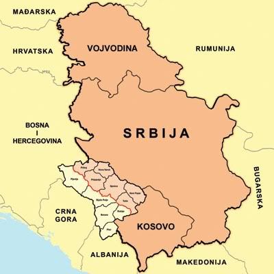
English: Map of Sandžak region in Serbia and Montenegro. Note: This map show Sandžak region in its largest geographical extent. According to some other views, Montenegrin municipalities of Plav and Andrijevica might not belong to Sandžak. Српски / srpski: Мапа Санџака у Србији и Црној Гори. Напомена: ова мапа приказује Санџак у највећем географском обиму. Према другим интерпретацијама, црногорске општине Плав и Андријевица не спадају у Санџак. |
| Data | |
| Burimi | Punë e juaja |
| Autori | PANONIAN |
Licencim
Unë, krijuesi i kësaj pune, e publikoj këtu në bazë të licensës në vijim:
| Kjo skedë është bërë e mundur nën Creative Commons CC0 1.0 Universal Public Domain Dedication. | |
| Personi që lidhi një punë me këtë vepër ia ka dedikuar punën public domain duke shmangur të gjitha të drejtat e tij apo të saj për punën në mbarë botën nën ligjin e të drejtës së autorit, duke përfshirë të gjitha të drejtat e lidhura dhe fqinje, deri në masën e lejuar me ligj. Ju mund ta kopjoni, modifikoni, shpërndani dhe të kryeni pune, madje edhe për qëllime komerciale, të gjitha pa kërkuar leje.
|
References
- Dr Tomislav Bogavac, Nestajanje Srba, Niš, 1994.
- http://www.bihor-petnica.com/Sandzak_Karta-zuta.gif
- http://www.bihor-petnica.com/sandzak-manja%20karta.jpg
- http://data36.sevenload.com/slcom/ww/mc/ciienk/eqzhjljbcdc.jpg
- http://www.radiosandzak.eu/FotoSandzaka/KartaSANDZAK.jpg
- http://www.bihor-petnica.com/Sandzak_u_Jugoslaviji.gif
- http://i1234.photobucket.com/albums/ff403/kedza1/BNV/PolozajSandzaka.jpg
- http://ligazasandzak.org/wp-content/uploads/2012/08/sandzak1.jpg
- http://sandzakbiznis.com/wordpress/sandzak.jpg
- http://api.ning.com/files/t7Mn40e4xGQfrLqZ9-1YGqqsl-TwYabCClIbqEOmuiBuVw7w1oO3KsZQzvrZF5gZPNhldyWJE-0zbOgJ9gXLQMezEgWVdtuV/Sandzakkartanova.jpg
- http://www.magasinetroest.dk/uploads/pics/Sandzak.jpg
- http://publishing.cdlib.org/ucpressebooks/data/13030/47/kt2k401947/figures/kt2k401947_fig003.gif
- http://t0.gstatic.com/images?q=tbn:ANd9GcQ1SPbXT6Y7H_F5h-sV6Fw0vOrnooACQtY3lyr_eZ4872CfvNnENA&t=1
- http://www.orbus.be/religion/islam/images/balkan-sandzak-300.jpg
- http://api.ning.com/files/aUR14cLVxZ6HUuLPtJyCnPRoHFWqnULDq4rRz3z-RnC2Ax5fZrFiilO-qrfofCtMn37ocGhe618*Ae8**Y7jI-IHym18ouA7/KartaSandzakaiSrbije.jpg
Historiku skedës
Shtypni mbi një datë/kohë për ta parë skedën siç ishte atëherë.
| Data/Koha | Miniaturë | Përmasat | Përdoruesi | Koment | |
|---|---|---|---|---|---|
| e tanishme | 8 qershor 2014 23:39 | | 974 × 930 (53 KB) | PANONIAN | {{Information |Description ={{en|1=Map of Sandžak region in Serbia and Montenegro. Note: This map show Sandžak region in its largest geographical extent. According to some other views, Montenegrin municipalities of Plav and Andrijevica might not b... |
Lidhje skedash
Këto faqe lidhen tek kjo skedë:
Përdorimi global i skedës
Kjo skedë përdoret nga Wiki të tjera në vijim:
- Përdorimi në sr.wikipedia.org