Skeda:AGHRC (1890) - Carta XI - División política de Colombia, 1824.jpg

Madhësia e këtij shikimi: 746 × 600 pixel. Rezolucione të tjera: 299 × 240 pixel | 597 × 480 pixel | 955 × 768 pixel | 1.274 × 1.024 pixel | 2.547 × 2.048 pixel | 4.293 × 3.452 pixel.
Dokument origjinal ((përmasa 4.293 × 3.452 px, madhësia skedës: 5,8 MB, lloji MIME: image/jpeg))
| Kjo skedë është prej Wikimedia Commons dhe mund të përdoret nga projekte të tjera. Përshkrimi në këtë skedë në këtë faqe nuk është treguar më poshtë. | Shko tek faqja përshkruese në Commons |
_-_Carta_XI_-_Divisi%C3%B3n_pol%C3%ADtica_de_Colombia,_1824.jpg)
_-_Carta_X_-_Guerras_de_independencia_en_Ecuador,_Per%C3%BA_y_Bolivia,_1823-1826.jpg)
_-_Carta_XII_-_Divisi%C3%B3n_pol%C3%ADtica_de_la_Nueva_Granada,_1851.jpg)
Përmbledhje
| Përshkrimi |
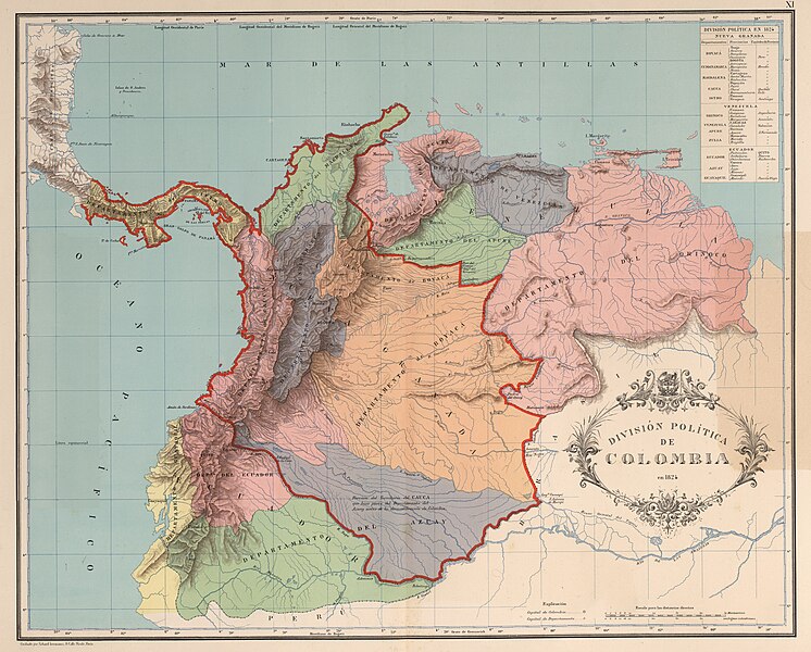
English: Political division of (Greater) Colombia in 1824. Map XI of the Geographic and Historic Atlas of the Republic of Colombia, 1890.
Español: División política de (la Gran) Colombia en 1824. Carta XI del Atlas geográfico e histórico de la República de Colombia, 1890.
Français : Division politique de (la Grande) Colombie en 1824. Carte XI de l'Atlas géographique et historique de la Republique de Colombie, 1890. |
| Data | |
| Burimi |
Atlas geográfico e histórico de la República de Colombia, 1890. http://www.lablaa.org/blaavirtual/revistas/credencial/junio1993/junio1.htm |
| Autori | Agustín Codazzi, Manuel Maria Paz, Felipe Pérez |
Licencim
This file is in the public domain because the copyright of this work, registered in Colombia, has expired, according to “Law 23 of 1982 on Copyright, Articles 11, 21-29”, amended by “Law 44 of 1993, Article 2” and “Law 1520 of 2012, Articles 4, 6 and 10” (details). However, some restrictions have to be addressed:
|

|
Historiku skedës
Shtypni mbi një datë/kohë për ta parë skedën siç ishte atëherë.
| Data/Koha | Miniaturë | Përmasat | Përdoruesi | Koment | |
|---|---|---|---|---|---|
| e tanishme | 4 dhjetor 2018 21:09 | | 4.293 × 3.452 (5,8 MB) | Milenioscuro | high quality (from David Rumsey) |
| 20 mars 2009 06:07 |  | 2.829 × 2.315 (2,75 MB) | Milenioscuro | nuevo mapa mayor resolucion | |
| 24 maj 2007 02:23 |  | 600 × 431 (58 KB) | Scaravid | {{Information |Description= División política de la gran colombia en 1824 |Source= http://www.lablaa.org/blaavirtual/revistas/credencial/junio1993/junio1.htm |Date= |Author= Agustín Codazzi |Permission= |other_versions= }} |
Lidhje skedash
Përdorimi global i skedës
Kjo skedë përdoret nga Wiki të tjera në vijim:
- Përdorimi në als.wikipedia.org
- Përdorimi në ar.wikipedia.org
- Përdorimi në azb.wikipedia.org
- Përdorimi në be-tarask.wikipedia.org
- Përdorimi në bn.wikipedia.org
- Përdorimi në br.wikipedia.org
- Përdorimi në da.wikipedia.org
- Përdorimi në de.wikipedia.org
- Përdorimi në el.wikipedia.org
- Përdorimi në en.wikipedia.org
- Përdorimi në es.wikipedia.org
- Përdorimi në fa.wikipedia.org
- Përdorimi në fi.wikipedia.org
- Përdorimi në fr.wikipedia.org
- Përdorimi në gd.wikipedia.org
- Përdorimi në gl.wikipedia.org
- Përdorimi në id.wikipedia.org
- Përdorimi në io.wikipedia.org
- Përdorimi në it.wikipedia.org
- Përdorimi në ja.wikipedia.org
- Përdorimi në mk.wikipedia.org
- Përdorimi në mzn.wikipedia.org
- Përdorimi në nl.wikipedia.org
- Përdorimi në pl.wikipedia.org
Shikoni më shumë përdorim global të kësaj skede.
_-_Carta_XI_-_Divisi%C3%B3n_pol%C3%ADtica_de_Colombia,_1824.jpg)
_-_Carta_XI_-_División_política_de_Colombia,_1824.jpg)