Skeda:Abbasid Caliphate 850AD.png
Madhësia e këtij shikimi: 800 × 497 pixel. Rezolucione të tjera: 320 × 199 pixel | 640 × 398 pixel | 1.024 × 637 pixel | 1.280 × 796 pixel | 2.163 × 1.345 pixel.
Dokument origjinal ((përmasa 2.163 × 1.345 px, madhësia skedës: 798 KB, lloji MIME: image/png))
| Kjo skedë është prej Wikimedia Commons dhe mund të përdoret nga projekte të tjera. Përshkrimi në këtë skedë në këtë faqe nuk është treguar më poshtë. | Shko tek faqja përshkruese në Commons |
Përmbledhje
| Përshkrimi |
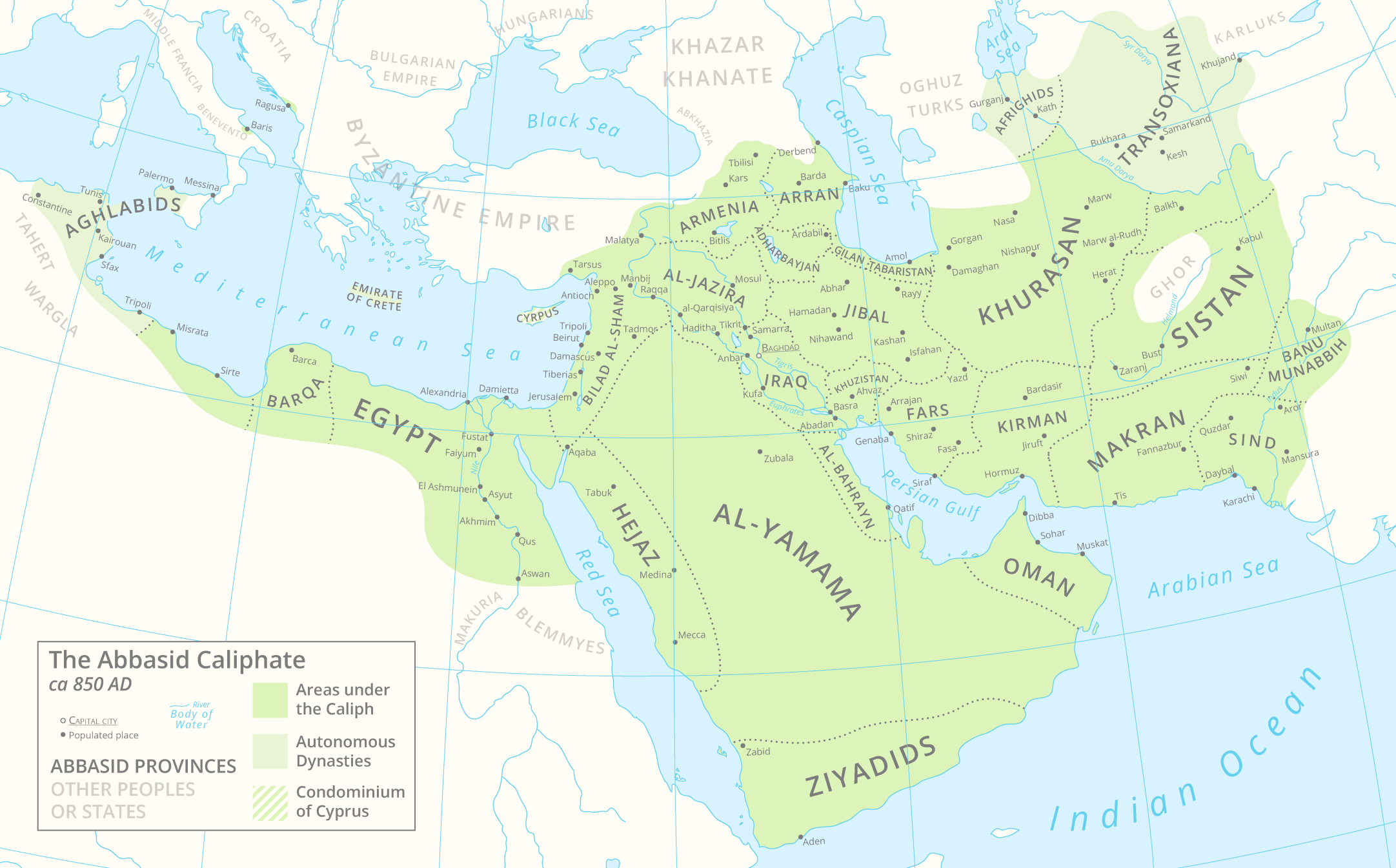
English: A map of the Abbasid Caliphate around 850 AD featuring provinces and settlements. |
| Data | |
| Burimi |
Punë e juaja.
This PNG graphic was created with Adobe Illustrator. |
| Autori | Cattette |
| Versione tjera | العربيَّة |
Licencim
Unë, krijuesi i kësaj pune, e publikoj këtu në bazë të licensës në vijim:
This file is licensed under the Creative Commons Attribution 4.0 International license.
- Je i lirë të:
- ta shpërndani – ta kopjoni, rishpërndani dhe përcillni punën
- t’i bëni “remix” – të përshtatni punën
- Sipas kushteve të mëposhtme:
- atribuim – Duhet t’i jepni meritat e duhura, të siguroni një lidhje për tek licenca dhe të tregoni nëse janë bërë ndryshime. Këtë mund ta bëni në ndonjë mënyrë të arsyeshme, por jo në ndonjë mënyrë që sugjeron se licencuesi ju del zot juve apo përdorimit tuaj.
Historiku skedës
Shtypni mbi një datë/kohë për ta parë skedën siç ishte atëherë.
| Data/Koha | Miniaturë | Përmasat | Përdoruesi | Koment | |
|---|---|---|---|---|---|
| e tanishme | 29 mars 2021 15:05 | | 2.163 × 1.345 (798 KB) | Cattette | Tweaked provinces, added Arabia |
| 17 mars 2021 10:13 |  | 2.163 × 1.052 (691 KB) | Cattette | Tweaked provinces | |
| 16 mars 2021 14:05 |  | 2.163 × 1.052 (690 KB) | Cattette | More provinces | |
| 15 mars 2021 08:10 |  | 2.163 × 1.052 (666 KB) | Cattette | Added more cities, removed the Canal of the Pharaohs, added more divisions | |
| 10 mars 2021 23:48 |  | 2.105 × 1.052 (508 KB) | Cattette | Uploaded own work with UploadWizard |
Lidhje skedash
Këto faqe lidhen tek kjo skedë:
Përdorimi global i skedës
Kjo skedë përdoret nga Wiki të tjera në vijim:
- Përdorimi në ar.wikipedia.org
- Përdorimi në ast.wikipedia.org
- Përdorimi në az.wikipedia.org
- Përdorimi në bn.wikipedia.org
- Përdorimi në ca.wikipedia.org
- Përdorimi në cs.wikipedia.org
- Përdorimi në de.wikipedia.org
- Përdorimi në diq.wikipedia.org
- Përdorimi në el.wikipedia.org
- Përdorimi në en.wikipedia.org
- Përdorimi në es.wikipedia.org
- Përdorimi në eu.wikipedia.org
- Përdorimi në fa.wikipedia.org
- Përdorimi në fi.wikipedia.org
- Përdorimi në ga.wikipedia.org
- Përdorimi në gl.wikipedia.org
- Përdorimi në ha.wikipedia.org
- Përdorimi në ia.wikipedia.org
- Përdorimi në ko.wikipedia.org
- Përdorimi në lt.wikipedia.org
- Përdorimi në lv.wikipedia.org
- Përdorimi në mg.wikipedia.org
- Përdorimi në mn.wikipedia.org
- Përdorimi në ms.wikipedia.org
- Përdorimi në pnb.wikipedia.org
- Përdorimi në pt.wikipedia.org
- Përdorimi në ro.wikipedia.org
- Përdorimi në shi.wikipedia.org
- Përdorimi në ta.wikipedia.org
- Përdorimi në th.wikipedia.org
- Përdorimi në tr.wikipedia.org
- Përdorimi në uk.wikipedia.org
- Përdorimi në ur.wikipedia.org
Shikoni më shumë përdorim global të kësaj skede.