Skeda:Byzantine empire 1355.jpg

Madhësia e këtij shikimi: 758 × 600 pixel. Rezolucione të tjera: 304 × 240 pixel | 607 × 480 pixel | 971 × 768 pixel | 1.134 × 897 pixel.
Dokument origjinal ((përmasa 1.134 × 897 px, madhësia skedës: 380 KB, lloji MIME: image/jpeg))
| Kjo skedë është prej Wikimedia Commons dhe mund të përdoret nga projekte të tjera. Përshkrimi në këtë skedë në këtë faqe nuk është treguar më poshtë. | Shko tek faqja përshkruese në Commons |
Përmbledhje
| Përshkrimi |
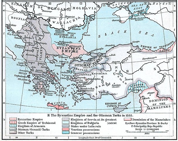
English: Map of the Byzantine, Ottoman and Serbian empires and their neighboring states, 1355. |
||||||||||||||||||||||
| Data | |||||||||||||||||||||||
| Burimi | William R. Shepherd's Historical Atlas, p. 89, published by Henry Holt and Company, New York 1911 | ||||||||||||||||||||||
| Autori |
|
||||||||||||||||||||||
| Versione tjera |
|
||||||||||||||||||||||

Licencim
This work is in the public domain in the United States because it was published (or registered with the U.S. Copyright Office) before January 1, 1929.
Public domain works must be out of copyright in both the United States and in the source country of the work in order to be hosted on the Commons. If the work is not a U.S. work, the file must have an additional copyright tag indicating the copyright status in the source country.
Note: This tag should not be used for sound recordings. |
Historiku skedës
Shtypni mbi një datë/kohë për ta parë skedën siç ishte atëherë.
| Data/Koha | Miniaturë | Përmasat | Përdoruesi | Koment | |
|---|---|---|---|---|---|
| e tanishme | 6 dhjetor 2022 22:53 | | 1.134 × 897 (380 KB) | Gyalu22 | Artwork |
| 29 mars 2018 18:44 |  | 1.112 × 879 (908 KB) | Nihil scimus | Few improving (esthetic, contrast, genoese possessions 1355 since Westermann Grosser Atlas zur Weltgeschichte, 1985, ISBN 3-14-100919-8, p. 70, wallachian possessions 1355 under Nicholas Alexander [https://commons.wikimedia.org/wiki/File:Nicolae_Alexandru.jpg] since [https://en.wikipedia.org/wiki/Wallachia#/media/File:Wallachia_13-16c.svg]). | |
| 8 nëntor 2009 15:17 |  | 1.134 × 897 (380 KB) | Alex:D | whitened | |
| 3 dhjetor 2005 18:00 |  | 1.134 × 897 (269 KB) | Migdejong | Map of the Byzantine Empire in the year 1355. Image comes from the University of Texas at Austin: http://geography.about.com/gi/dynamic/offsite.htm?site=http://www.lib.utexas.edu/maps/historical/history%5Feurope.html Map is released into the public |
Lidhje skedash
Këto faqe lidhen tek kjo skedë:
Përdorimi global i skedës
Kjo skedë përdoret nga Wiki të tjera në vijim:
- Përdorimi në ar.wikipedia.org
- Përdorimi në azb.wikipedia.org
- Përdorimi në az.wikipedia.org
- Përdorimi në ba.wikipedia.org
- Përdorimi në bg.wikipedia.org
- Përdorimi në bs.wikipedia.org
- Përdorimi në ca.wikipedia.org
- Përdorimi në de.wikipedia.org
- Byzantinisches Reich
- Makedonien
- 1355
- Großserbien
- Marino Falier
- Andronikos IV.
- Beylik von Aydın
- Eroberung von Philadelphia
- Eroberung von Gallipoli
- Byzantinisch-genuesischer Krieg (1348–1349)
- Byzantinischer Bürgerkrieg (1352–1357)
- Byzantinischer Bürgerkrieg (1373–1381)
- Kreuzzug von Smyrna
- Benutzer:GerardM/Battles including the Ottoman Empire
- Përdorimi në el.wikipedia.org
- Përdorimi në en.wikipedia.org
Shikoni më shumë përdorim global të kësaj skede.