Dokument origjinal((përmasa 1.530 × 1.710 px, madhësia skedës: 699 KB, lloji MIME: image/jpeg))

Kjo skedë është prej Wikimedia Commons dhe mund të përdoret nga projekte të tjera. Përshkrimi në këtë skedë në këtë faqe nuk është treguar më poshtë. Shko tek faqja përshkruese në Commons Shko tek faqja përshkruese në Commons

Përmbledhje

Përshkrimi
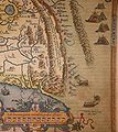
English: Detail of the map of China engraved by Abraham Ortelius (1584), the first map of China printed in a European atlas. "C.Paquin" is Beijing (Peking).

The Latin text next to the Great Wall says: "Murus quadringentarum leucarum inter montium crepidines a Rege Chinæ contra Tartarorum ab hac parte eruptiones extructus."

Translation to English: "A wall of four hundred miles has been constructed between the edges of the mountains by the King of China against the invasions of the Tartars in this part."
Deutsch: Detailaufnahme von der China-Karte von Abraham Ortelius (1584), der ersten in einem abendländischen Atlas erscheinenden Karte von China. Die Karte ist nach Westen ausgerichtet. Die Chinesische Mauer verläuft auf einer Länge von etwa 400 Meilen (also viel zu kurz). Rechts, also im Norden, sind schöne mongolische Jurten zu sehen. Man beachte auch die Windwagen, die in China schon im 6. Jahrhundert nach Christus entwickelt worden sind.

Der lateinische Text entlang der Chinesischen Mauer lautet: "Murus quadringentarum leucarum inter montium crepidines a Rege Chinæ contra Tartarorum ab hac parte eruptiones extructus."

Auf Deutsch übersetzt: "Eine vierhundert Meilen lange Mauer wurde zwischen den Bergkämmen vom König von China gegen die Invasionen der Ta(r)taren in diesem Gebiet erstellt."
Data
Burimi Private collection
institution QS:P195,Q768717
Autori
Abraham Ortelius  (1527–1598)  wikidata:Q232916 s:it:Autore:Abraham Ortelius
 
Abraham Ortelius
Emrat alternative
Ortels, Oertel, Orthellius, Wortels
Përshkrimi cartographer, historian, engraver, gjeograf, arkeolog dhe afsetter
Data e lindjes/vdekjes 14 prill 1527 Edit this at Wikidata 28 qershor 1598 / 29 qershor 1598 Edit this at Wikidata
Vendi e lindjes/vdekjes Antwerp Antwerp
Vendndodhja e punës
Authority file
creator QS:P170,Q232916
Versione tjera Entire map:

Licencim

Public domain

This work is in the public domain in its country of origin and other countries and areas where the copyright term is the author's life plus 100 years or fewer.


You must also include a United States public domain tag to indicate why this work is in the public domain in the United States.

Captions

Add a one-line explanation of what this file represents

Items portrayed in this file

përshkruan

image/jpeg

checksum anglisht

d88a96d732ef8ac9a75d65fa5d945f66d77ad3d1

data size anglisht

715.439 Bajti

1.710 pixel

1.530 pixel

Historiku skedës

Shtypni mbi një datë/kohë për ta parë skedën siç ishte atëherë.

Data/KohaMiniaturëPërmasatPërdoruesiKoment
e tanishme2 mars 2009 20:13Miniaturë për versionin duke filluar nga 2 mars 2009 20:131.530 × 1.710 (699 KB)Altiplano{{Information |Description={{en|1=Detail of the map of China engraved by Abraham Ortelius (1584), the first map of China printed in a european atlas. The latin text next to the Great Wall sais: "Murus quadringentarum leucarum inter montium crepidines a Re

Këto faqe lidhen tek kjo skedë:

Përdorimi global i skedës

Kjo skedë përdoret nga Wiki të tjera në vijim:

Metadata