Skeda:Fimmvorduhals 2010 03 27 dawn.jpg

Madhësia e këtij shikimi: 800 × 533 pixel. Rezolucione të tjera: 320 × 213 pixel | 640 × 426 pixel | 1.024 × 682 pixel | 1.280 × 852 pixel | 2.560 × 1.705 pixel | 4.752 × 3.164 pixel.
Dokument origjinal ((përmasa 4.752 × 3.164 px, madhësia skedës: 13,86 MB, lloji MIME: image/jpeg))
| Kjo skedë është prej Wikimedia Commons dhe mund të përdoret nga projekte të tjera. Përshkrimi në këtë skedë në këtë faqe nuk është treguar më poshtë. | Shko tek faqja përshkruese në Commons |
Përmbledhje
| Përshkrimi |
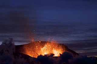
English: Eruption at Fimmvörðuháls at dusk.
Deutsch: Vulkanausbruch auf dem Fimmvörðuháls in der Dämmerung.
Français : Éruption du volcan Eyjafjöll au niveau du col de Fimmvörðuháls au crépuscule.
Bahasa Indonesia: Erupsi di Gunung Fimmvörðuháls. |
| Data | |
| Burimi | Punë e juaja |
| Autori | Boaworm |
| Camera location | | View this and other nearby images on: OpenStreetMap |
|---|
|

This image was selected as picture of the day on Wikimedia Commons for 2 November 2010. It was captioned as follows: English: Eruption at Fimmvörðuháls at dusk. Other languages:
Deutsch: Vulkanausbruch auf dem Fimmvörðuháls in der Dämmerung. English: Eruption at Fimmvörðuháls at dusk. Español: Erupción en Fimmvörðuháls al atardecer. Français : Éruption du volcan Eyjafjöll au niveau du col de Fimmvörðuháls au crépuscule. Íslenska: Eldgos í Fimmvörðuhálsi að kvöldalagi. Magyar: Vulkánkitörés az izlandi Fimmvörðuháls (Öt Magaslat Hágó) régióban Nederlands: Uitbarsting van de Eyjafjallajökull gezien vanaf de IJslandse bergpas Fimmvörðuháls bij zonsondergang. Македонски: Ерупција во Фимвердухалс на квечерина. Русский: Извержение Fimmvörðuháls в сумерках. 한국어: 어스름에 에이야피아들라예퀴들이 분화하는 모습. 2010년 3월 27일 촬영. 日本語: アイスランドのフィムヴォルズハウルスにおけるエイヤフィヤトラヨークトルの噴火。2010年3月27日撮影。 中文: 菲姆沃罗豪尔斯火山喷发 |
Licencim
Unë, krijuesi i kësaj pune, e publikoj këtu në bazë të licensës në vijim:
Kjo skedë është dhënë për përdorim sipas licensës Creative Commons Attribution 3.0 Unported.
- Je i lirë të:
- ta shpërndani – ta kopjoni, rishpërndani dhe përcillni punën
- t’i bëni “remix” – të përshtatni punën
- Sipas kushteve të mëposhtme:
- atribuim – Duhet t’i jepni meritat e duhura, të siguroni një lidhje për tek licenca dhe të tregoni nëse janë bërë ndryshime. Këtë mund ta bëni në ndonjë mënyrë të arsyeshme, por jo në ndonjë mënyrë që sugjeron se licencuesi ju del zot juve apo përdorimit tuaj.
Historiku skedës
Shtypni mbi një datë/kohë për ta parë skedën siç ishte atëherë.
| Data/Koha | Miniaturë | Përmasat | Përdoruesi | Koment | |
|---|---|---|---|---|---|
| e tanishme | 28 tetor 2010 02:32 | | 4.752 × 3.164 (13,86 MB) | Nergaal | Reverted to version as of 10:18, 16 April 2010 |
| 28 tetor 2010 01:39 |  | 4.444 × 2.304 (3,61 MB) | John Aplessed | * Image has been cropped. * Image has been saturated. * Image has been sharpened. * Image has been optimised, reducing file size dramatically and decreasing load times. | |
| 16 prill 2010 12:18 |  | 4.752 × 3.164 (13,86 MB) | Boaworm | {{Information |Description={{en|1=Eruption at Fimmvörðuháls at dawn.}} |Source={{own}} |Author=Boaworm |Date=2010-03-27 |Permission= |other_versions= }} Latitude: 63.632875° N Longitude: 19.433594° W Category:Volcanoes of Iceland |
Lidhje skedash
Këto faqe lidhen tek kjo skedë:
Përdorimi global i skedës
Kjo skedë përdoret nga Wiki të tjera në vijim:
- Përdorimi në am.wikipedia.org
- Përdorimi në an.wikipedia.org
- Përdorimi në ba.wikipedia.org
- Përdorimi në be-tarask.wikipedia.org
- Përdorimi në be.wikipedia.org
- Përdorimi në bg.wikipedia.org
- Përdorimi në bn.wikipedia.org
- Përdorimi në br.wikipedia.org
- Përdorimi në bs.wikipedia.org
- Përdorimi në crh.wikipedia.org
- Përdorimi në cs.wikipedia.org
- Përdorimi në cv.wikipedia.org
- Përdorimi në da.wikipedia.org
- Përdorimi në de.wikipedia.org
- Përdorimi në el.wikipedia.org
- Përdorimi në en.wikipedia.org
- Eyjafjallajökull
- Portal:Iceland/Selected picture
- Fimmvörðuháls
- User:Daniel Mietchen/Science communication gallery
- User:Boaworm
- User talk:Boaworm
- Gas slug
- Portal:Iceland/Selected picture/14
- User:GeekyEnki/sandbox/Eyjafjallajökull
- List of volcanic eruptions in Iceland
- User:Dronebogus/Basement
- User:Pvera28/sandbox
- Përdorimi në en.wikiquote.org
- Përdorimi në es.wikipedia.org
- Përdorimi në eu.wikipedia.org
- Përdorimi në fa.wikipedia.org
- Përdorimi në fr.wikipedia.org
- Përdorimi në fr.wikinews.org
- Përdorimi në he.wikipedia.org
- Përdorimi në hi.wikipedia.org
- Përdorimi në hr.wikipedia.org
Shikoni më shumë përdorim global të kësaj skede.