Skeda:Italy and Illyria 1084 AD.svg

Size of this PNG preview of this SVG file: 478 × 600 pixel. Rezolucione të tjera: 191 × 240 pixel | 383 × 480 pixel | 612 × 768 pixel | 816 × 1.024 pixel | 1.633 × 2.048 pixel | 586 × 735 pixel.
Dokument origjinal (skedë SVG, fillimisht 586 × 735 pixel, madhësia e skedës: 522 KB)
| Kjo skedë është prej Wikimedia Commons dhe mund të përdoret nga projekte të tjera. Përshkrimi në këtë skedë në këtë faqe nuk është treguar më poshtë. | Shko tek faqja përshkruese në Commons |

Përmbledhje
| Përshkrimi |
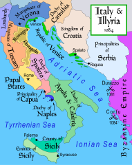
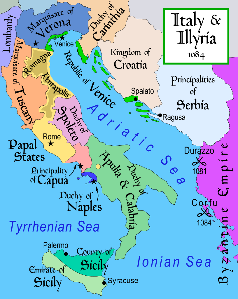
English: Map of Italy and the Illyrian coast in the year 1084.
Part of a series of maps on the history of Italy:
|
| Data | |
| Burimi | Punë e juaja |
| Autori | MapMaster |
| Versione tjera |
[]
|
| SVG genesis |


References
- This map from Allyn & Bacon, Longman, textbook publishers.
- Bjorklund, Oddvar; Holmboe, Haakon; Rohr, Anders (1970) Historical Atlas of the World, Barnes & Noble, NY, SBN: 389-00253-4.
- Hammond Atlas Corporation (2007) Hammond Historical World Atlas.
- Matthew, Donald (1989) Atlas of Medieval Europe, Time-Life Books.
- This map of 1000 AD Italy from Fordham University, adapted from Muir's Historical Atlas, (1911).
- This map of 1050 AD Italy, from the 1923 The Historical Atlas by William R. Shepherd
- This Wikipedia map of the w:en:Holy Roman Empire
- Šišić, Ferdo (1990) Povijest Hrvata u vrijeme narodnih vladara & the Baška tablet (to denote the territorial integrity of Croatia; islands, coastal borders etc.)
Licencim
Unë, krijuesi i kësaj pune, e publikoj këtu në bazë të licensës në vijim:
Kjo skedë është dhënë për përdorim sipas licensës Creative Commons Attribution-Share Alike 2.5 Generic.
- Je i lirë të:
- ta shpërndani – ta kopjoni, rishpërndani dhe përcillni punën
- t’i bëni “remix” – të përshtatni punën
- Sipas kushteve të mëposhtme:
- atribuim – Duhet t’i jepni meritat e duhura, të siguroni një lidhje për tek licenca dhe të tregoni nëse janë bërë ndryshime. Këtë mund ta bëni në ndonjë mënyrë të arsyeshme, por jo në ndonjë mënyrë që sugjeron se licencuesi ju del zot juve apo përdorimit tuaj.
- share alike – Nëse bëni një “remix”, e shndërroni, ose ndërtoni duke u bazuar te materiali, duhet t’i shpërndani kontributet tuaja sipas të njëjtës licencë ose një të tille të përputhshme me origjinalen.
derivative works
Derivative works of this file: Italy and Illyria 1084 v2-ar.svg
Historiku skedës
Shtypni mbi një datë/kohë për ta parë skedën siç ishte atëherë.
| Data/Koha | Miniaturë | Përmasat | Përdoruesi | Koment | |
|---|---|---|---|---|---|
| e tanishme | 22 tetor 2017 21:19 | | 586 × 735 (522 KB) | Ras67 | frame removed |
| 23 nëntor 2011 14:16 |  | 588 × 735 (644 KB) | Kathovo | Reverted to version as of 12:20, 29 July 2007 not an svg | |
| 23 janar 2011 20:06 |  | 480 × 600 (224 KB) | Er-vet-en | whoops, sorry for this | |
| 23 janar 2011 20:04 |  | 480 × 600 (224 KB) | Er-vet-en | resize | |
| 23 janar 2011 19:50 |  | 744 × 1.052 (224 KB) | Er-vet-en | plit and some islands are are actually in Croatia's dominion from about 1076 (since the previous map relied on maps from earlier) This is proven by the acclaimed historian Ferdo Šišić, and the culturally significant Bashka tablet (which proved that ki | |
| 29 korrik 2007 14:20 |  | 588 × 735 (644 KB) | Lokal Profil | Cleaned up code (specifically loads of empty groups) | |
| 15 prill 2007 07:43 |  | 588 × 735 (695 KB) | MapMaster | Minor changes | |
| 13 shkurt 2007 05:56 |  | 588 × 735 (694 KB) | MapMaster | Map of Italy and the Illyrian coast in the year 1084 |
Lidhje skedash
Këto faqe lidhen tek kjo skedë:
Përdorimi global i skedës
Kjo skedë përdoret nga Wiki të tjera në vijim:
- Përdorimi në ar.wikipedia.org
- Përdorimi në azb.wikipedia.org
- Përdorimi në bg.wikipedia.org
- Përdorimi në bn.wikipedia.org
- Përdorimi në bs.wikipedia.org
- Përdorimi në ca.wikipedia.org
- Përdorimi në cs.wikipedia.org
- Përdorimi në da.wikipedia.org
- Përdorimi në de.wikipedia.org
- Përdorimi në el.wikipedia.org
- Përdorimi në en.wikipedia.org
- Përdorimi në et.wikipedia.org
Shikoni më shumë përdorim global të kësaj skede.