Skeda:Location of the Ryukyu Islands.JPG
Madhësia e këtij shikimi: 654 × 599 pixel. Rezolucione të tjera: 262 × 240 pixel | 524 × 480 pixel.
Dokument origjinal ((përmasa 800 × 733 px, madhësia skedës: 310 KB, lloji MIME: image/jpeg))
| Kjo skedë është prej Wikimedia Commons dhe mund të përdoret nga projekte të tjera. Përshkrimi në këtë skedë në këtë faqe nuk është treguar më poshtë. | Shko tek faqja përshkruese në Commons |

|
Kjo locator map fotografi duhet duhen te behen edhe i here si nje SVG.
|


Përmbledhje
| Përshkrimi |
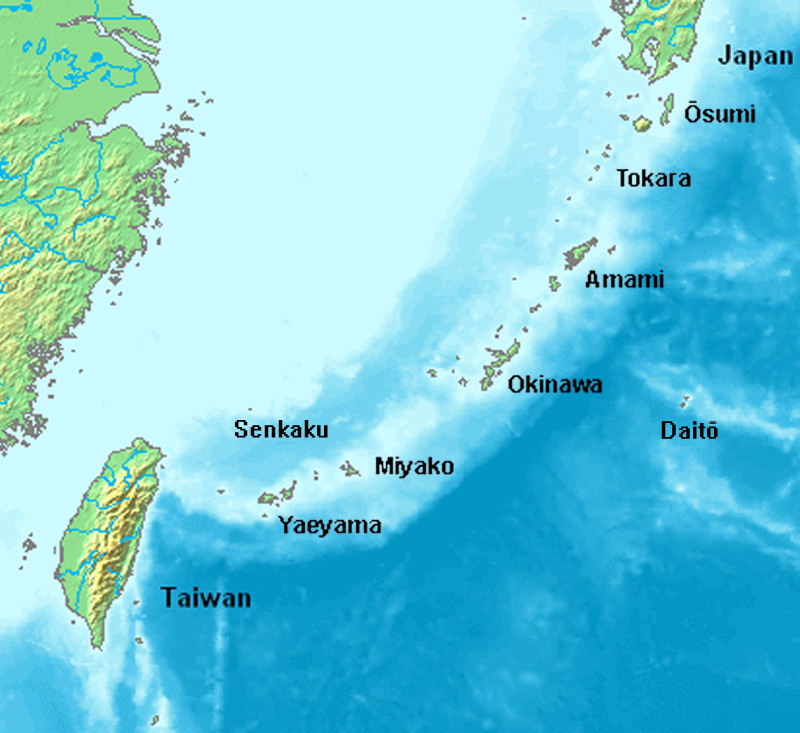
English: Location map of the Ryukyu islands (Nansei islands). This is a modification of the:
http://commons.wikimedia.org/wiki/Image:Location_Ryukyu_Islands.PNG |
| Data | June 2006 |
| Burimi | Punë e juaja |
| Autori | Uchinanchu |
| Versione tjera |
|

Licencim

|
The copyright holder of this work allows anyone to use it for any purpose including unrestricted redistribution, commercial use, and modification.
Usage notes:
|
Historiku skedës
Shtypni mbi një datë/kohë për ta parë skedën siç ishte atëherë.
| Data/Koha | Miniaturë | Përmasat | Përdoruesi | Koment | |
|---|---|---|---|---|---|
| e tanishme | 7 gusht 2019 18:43 | | 800 × 733 (310 KB) | Artanisen | Higher quality and larger version. |
| 28 qershor 2006 07:24 |  | 482 × 377 (47 KB) | Uchinanchu | Location of the Ryukyu Islands Modification of the: http://commons.wikimedia.org/wiki/Image:Location_Ryukyu_Islands.PNG |
Lidhje skedash
Këto faqe lidhen tek kjo skedë:
Përdorimi global i skedës
Kjo skedë përdoret nga Wiki të tjera në vijim:
- Përdorimi në af.wikipedia.org
- Përdorimi në ang.wikipedia.org
- Përdorimi në ar.wikipedia.org
- Përdorimi në ast.wikipedia.org
- Përdorimi në az.wikipedia.org
- Përdorimi në bg.wikipedia.org
- Përdorimi në bh.wikipedia.org
- Përdorimi në br.wikipedia.org
- Përdorimi në ca.wikipedia.org
- Përdorimi në cdo.wikipedia.org
- Përdorimi në da.wikipedia.org
- Përdorimi në de.wikipedia.org
- Ryūkyū-Inseln
- Geschichte der Ryūkyū-Inseln
- Nansei-Inseln
- Kerama-Inseln
- Diploderma polygonatum
- Plestiodon kishinouyei
- Sinomicrurus japonicus
- Eigentliche Zwergschlangen
- Calamaria pfefferi
- Achalinus werneri
- Lycodon multifasciatus
- Ptyas herminae
- Hebius pryeri
- Hebius ishigakiensis
- Hebius concelarus
- Gekko vertebralis
- Ateuchosaurus pellopleurus
- Scincella boettgeri
- Plestiodon japonicus
- Plestiodon marginatus
- Plestiodon latiscutatus
- Plestiodon finitimus
- Plestiodon kuchinoshimensis
- Plestiodon stimpsonii
- Plestiodon takarai
- Plestiodon oshimensis
- Buergeria japonica
- Japanisch-taiwanische Beziehungen
- Përdorimi në en.wikipedia.org
Shikoni më shumë përdorim global të kësaj skede.