Skeda:Public Schools Historical Atlas - Europe 1135.jpg

Madhësia e këtij shikimi: 773 × 600 pixel. Rezolucione të tjera: 309 × 240 pixel | 619 × 480 pixel | 990 × 768 pixel | 1.280 × 994 pixel | 2.234 × 1.734 pixel.
Dokument origjinal ((përmasa 2.234 × 1.734 px, madhësia skedës: 1.013 KB, lloji MIME: image/jpeg))
| Kjo skedë është prej Wikimedia Commons dhe mund të përdoret nga projekte të tjera. Përshkrimi në këtë skedë në këtë faqe nuk është treguar më poshtë. | Shko tek faqja përshkruese në Commons |
Përmbledhje
_en.png)
.png)
.jpg)
Licencim
This media file is in the public domain in the United States. This applies to U.S. works where the copyright has expired, often because its first publication occurred prior to January 1, 1929, and if not then due to lack of notice or renewal. See this page for further explanation.
|
 | |
 |
This image might not be in the public domain outside of the United States; this especially applies in the countries and areas that do not apply the rule of the shorter term for US works, such as Canada, Mainland China (not Hong Kong or Macao), Germany, Mexico, and Switzerland. The creator and year of publication are essential information and must be provided. See Wikipedia:Public domain and Wikipedia:Copyrights for more details.
|
Historiku skedës
Shtypni mbi një datë/kohë për ta parë skedën siç ishte atëherë.
| Data/Koha | Miniaturë | Përmasat | Përdoruesi | Koment | |
|---|---|---|---|---|---|
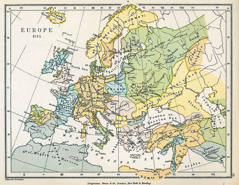
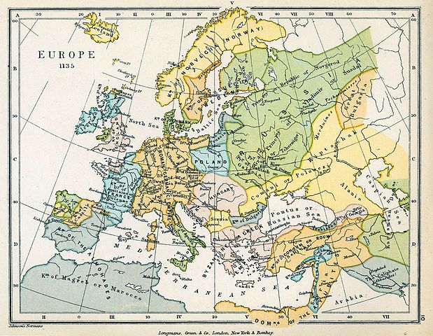
| e tanishme | 18 qershor 2009 20:26 | | 2.234 × 1.734 (1.013 KB) | Yarl | == {{int:filedesc}} == {{Information |Description={{en|Map of Europe in 1135.}} |Source= * ''The Public Schools Historical Atlas'' by Charles Colbeck. Longmans, Green; New York; London; Bombay. 1905. * [http://www.lib.utexas.edu/maps/historical/history_co |
Lidhje skedash
Këto faqe lidhen tek kjo skedë:
Përdorimi global i skedës
Kjo skedë përdoret nga Wiki të tjera në vijim:
- Përdorimi në be-tarask.wikipedia.org
- Përdorimi në el.wikipedia.org
- Përdorimi në en.wikipedia.org
- Përdorimi në pt.wikipedia.org
- Përdorimi në scn.wikipedia.org
- Përdorimi në sh.wikipedia.org
- Përdorimi në sl.wikipedia.org
- Përdorimi në sr.wikipedia.org
- Përdorimi në th.wikipedia.org