Skeda:Satellite image of Hokkaido, Japan in May 2001.jpg

Madhësia e këtij shikimi: 450 × 600 pixel. Rezolucione të tjera: 180 × 240 pixel | 360 × 480 pixel | 576 × 768 pixel | 768 × 1.024 pixel | 2.400 × 3.200 pixel.
Dokument origjinal ((përmasa 2.400 × 3.200 px, madhësia skedës: 466 KB, lloji MIME: image/jpeg))
| Kjo skedë është prej Wikimedia Commons dhe mund të përdoret nga projekte të tjera. Përshkrimi në këtë skedë në këtë faqe nuk është treguar më poshtë. | Shko tek faqja përshkruese në Commons |
Përmbledhje
| Përshkrimi |
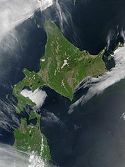
English: Satellite image of Hokkaido, Japan in May 2001. Taken from NASA's Visible Earth http://visibleearth.nasa.gov/view_rec.php?id=2060. This MODIS true-color image shows Hokkaido, Japan, at the top, and the northern tip of the island off Honshu at the bottom. Русский: Спутниковый снимок Хоккайдо (спутник Терра, NASA MODIS; май 2001 года) |
| Data | |
| Burimi | NASA |
| Autori | NASA |
Licencim
| This file is in the public domain in the United States because it was solely created by NASA. NASA copyright policy states that "NASA material is not protected by copyright unless noted". (See Template:PD-USGov, NASA copyright policy page or JPL Image Use Policy.) | ||
 |
Warnings:
|
derivative works
Derivative works of this file: Akan volcano meakan-dake hokkaido japan space shot.jpg
| Annotations | This image is annotated: View the annotations at Commons |
Historiku skedës
Shtypni mbi një datë/kohë për ta parë skedën siç ishte atëherë.
| Data/Koha | Miniaturë | Përmasat | Përdoruesi | Koment | |
|---|---|---|---|---|---|
| e tanishme | 7 maj 2006 23:50 | | 2.400 × 3.200 (466 KB) | Akanemoto~commonswiki | Satellite image of Hokkaido, Japan in May 2001. Taken from NASA's Visible Earth http://visibleearth.nasa.gov/view_rec.php?id=2060 |
Lidhje skedash
Këto faqe lidhen tek kjo skedë:
Përdorimi global i skedës
Kjo skedë përdoret nga Wiki të tjera në vijim:
- Përdorimi në af.wikipedia.org
- Përdorimi në ar.wikipedia.org
- Përdorimi në arz.wikipedia.org
- Përdorimi në ast.wikipedia.org
- Përdorimi në bo.wikipedia.org
- Përdorimi në ca.wikipedia.org
- Përdorimi në en.wikipedia.org
- Përdorimi në en.wiktionary.org
- Përdorimi në eu.wikipedia.org
- Përdorimi në fr.wikipedia.org
- Përdorimi në ga.wikipedia.org
- Përdorimi në gl.wikipedia.org
- Përdorimi në ha.wikipedia.org
- Përdorimi në hy.wikipedia.org
- Përdorimi në id.wikipedia.org
- Përdorimi në incubator.wikimedia.org
- Përdorimi në it.wikipedia.org
- Përdorimi në ja.wikipedia.org
- Përdorimi në ja.wikibooks.org
- Përdorimi në ko.wikipedia.org
- Përdorimi në la.wikipedia.org
- Përdorimi në ml.wikipedia.org
- Përdorimi në nn.wikipedia.org
- Përdorimi në oc.wikipedia.org
- Përdorimi në pam.wikipedia.org
- Përdorimi në pl.wikipedia.org
- Përdorimi në pl.wiktionary.org
- Përdorimi në pnb.wikipedia.org
- Përdorimi në pt.wikipedia.org
- Përdorimi në ru.wikipedia.org
- Përdorimi në ru.wikinews.org
- Përdorimi në sco.wikipedia.org
- Përdorimi në simple.wikipedia.org
- Përdorimi në sr.wikipedia.org
- Përdorimi në sv.wikipedia.org
- Përdorimi në szl.wikipedia.org
- Përdorimi në ta.wikipedia.org
- Përdorimi në tg.wikipedia.org
- Përdorimi në uk.wikipedia.org
- Përdorimi në ur.wikipedia.org
- Përdorimi në vec.wikipedia.org
- Përdorimi në vi.wikipedia.org
Shikoni më shumë përdorim global të kësaj skede.