Skeda:Slaven.jpg
Dokument origjinal ((përmasa 3.216 × 2.754 px, madhësia skedës: 5,22 MB, lloji MIME: image/jpeg))
| Kjo skedë është prej Wikimedia Commons dhe mund të përdoret nga projekte të tjera. Përshkrimi në këtë skedë në këtë faqe nuk është treguar më poshtë. | Shko tek faqja përshkruese në Commons |
Përmbledhje
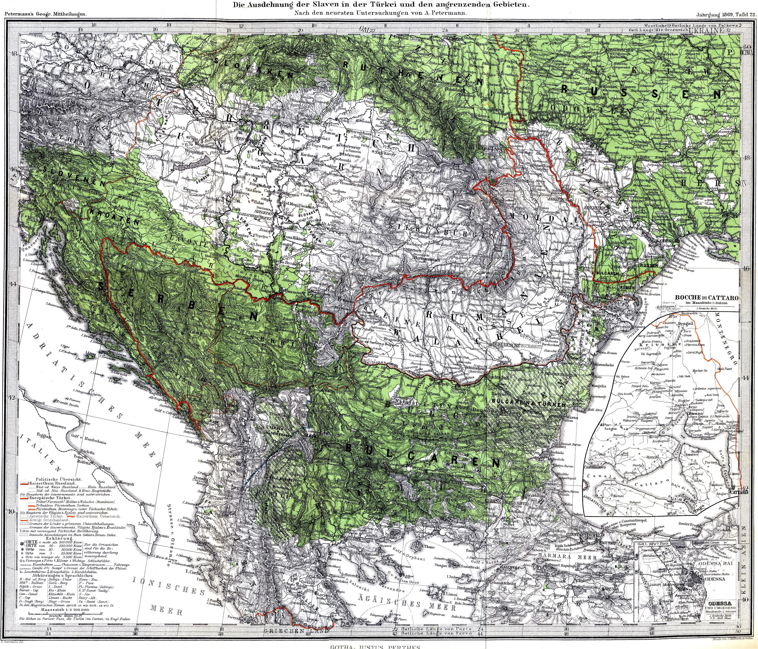
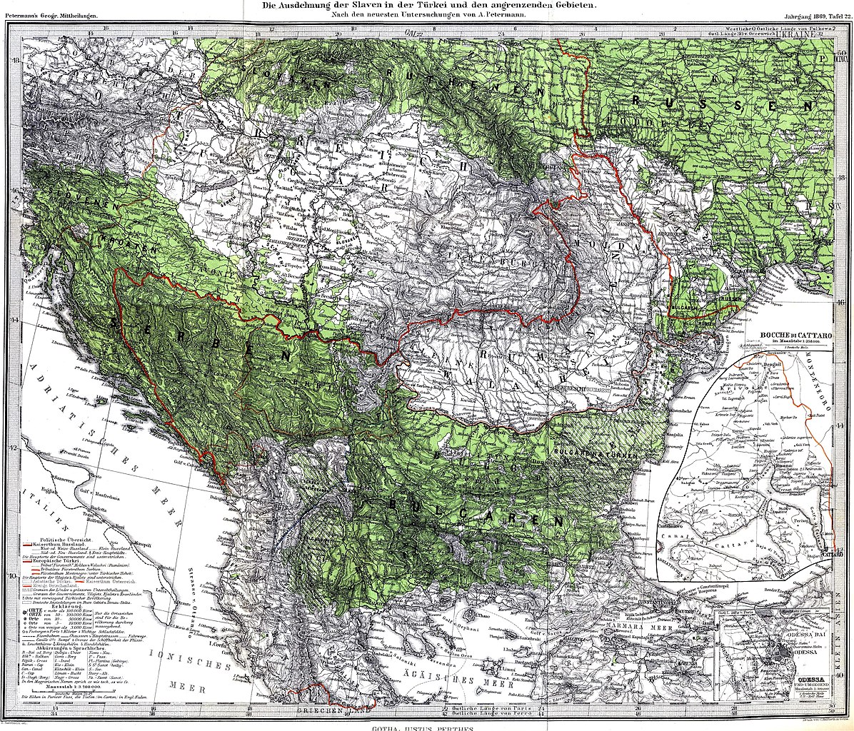
| Përshkrimi | The Spread of Slavs in the Balkan Peninsula and the Carpathian-Danubian space, 1869. The author of this map was the renowned cartographer August Heinrich Petermann. According to Henry Robert Wilkinson (Maps and politics: a review of the ethnographic cartography of Macedonia, Liverpool, England : University Press, 1951, p. 55.) the author of the explanatory text to the map was the Croatian ethnographer prof. F. Bradashka. |
| Data | |
| Burimi | Petermanns Mitteilungen |
| Autori | August Heinrich Petermann |
Licencim
|
This work is in the public domain in its country of origin and other countries and areas where the copyright term is the author's life plus 70 years or fewer.
| |
| Kjo skedë është identifikuar si e lirë e kufizimeve të panjohura në ligjin e të drejtave të autorit, duke përfshirë të gjitha të drejtat e lidhura dhe fqinje. | |
Historiku skedës
Shtypni mbi një datë/kohë për ta parë skedën siç ishte atëherë.
| Data/Koha | Miniaturë | Përmasat | Përdoruesi | Koment | |
|---|---|---|---|---|---|
| e tanishme | 5 shtator 2021 19:34 | | 3.216 × 2.754 (5,22 MB) | Claude Zygiel | Contrast & cosmetic |
| 8 dhjetor 2009 23:53 |  | 3.216 × 2.754 (5,01 MB) | Alex:D | whitened | |
| 6 maj 2008 02:37 |  | 3.216 × 2.754 (5,1 MB) | Olahus | {{Information |Description=The Spread of Slavs in the Balkan Peninsula and the Carpathian-Danubian space. |Source=Petermanns Mitteilungen |Date=1869 |Author=own scan |Permission= |other_versions= }} Category:Maps in German [[Category:Lin |
Lidhje skedash
Këto faqe lidhen tek kjo skedë:
Përdorimi global i skedës
Kjo skedë përdoret nga Wiki të tjera në vijim:
- Përdorimi në bg.wikipedia.org
- Përdorimi në de.wikipedia.org
- Përdorimi në en.wikipedia.org
- Përdorimi në fr.wikipedia.org
- Përdorimi në pl.wikipedia.org
- Përdorimi në pt.wikipedia.org
- Përdorimi në ro.wikipedia.org
- Përdorimi në ru.wikipedia.org
- Përdorimi në uk.wikipedia.org