Skeda:We-map.png

Madhësia e këtij shikimi: 275 × 600 pixel. Rezolucione të tjera: 110 × 240 pixel | 326 × 711 pixel.
Dokument origjinal ((përmasa 326 × 711 px, madhësia skedës: 22 KB, lloji MIME: image/png))
| Kjo skedë është prej Wikimedia Commons dhe mund të përdoret nga projekte të tjera. Përshkrimi në këtë skedë në këtë faqe nuk është treguar më poshtë. | Shko tek faqja përshkruese në Commons |
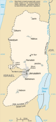
Përmbledhje
| Përshkrimi |
English: Replacement map of the West Bank from CIA Factbook |
| Burimi | The original GIF image source for this map is: archive copy at the Wayback Machine |
| Autori | This PNG image was copied from en.wikipedia.org. |
This image is in the public domain because it contains materials that originally came from the United States Central Intelligence Agency's World Factbook.
|
 |
Historiku skedës
Shtypni mbi një datë/kohë për ta parë skedën siç ishte atëherë.
| Data/Koha | Miniaturë | Përmasat | Përdoruesi | Koment | |
|---|---|---|---|---|---|
| e tanishme | 25 mars 2010 15:56 | | 326 × 711 (22 KB) | Ras67 | cropped |
| 15 shtator 2004 14:35 |  | 330 × 715 (23 KB) | Robbot | This image was copied from en.wikipedia.org. The original description was: Replacement map of the West Bank from CIA Factbook - public domain en:Image:We-map.png {{PD-USgov}} |
Lidhje skedash
S’ka faqe që përdorin këtë kartelë.
Përdorimi global i skedës
Kjo skedë përdoret nga Wiki të tjera në vijim:
- Përdorimi në af.wikipedia.org
- Përdorimi në als.wikipedia.org
- Përdorimi në ar.wikinews.org
- Përdorimi në ast.wikipedia.org
- Përdorimi në be-tarask.wikipedia.org
- Përdorimi në be.wikipedia.org
- Përdorimi në bg.wikipedia.org
- Përdorimi në br.wikipedia.org
- Përdorimi në bs.wikipedia.org
- Përdorimi në ca.wikipedia.org
- Përdorimi në ce.wikipedia.org
- Përdorimi në cs.wikipedia.org
- Përdorimi në cy.wikipedia.org
- Përdorimi në da.wikipedia.org
- Përdorimi në el.wikipedia.org
- Përdorimi në en.wikipedia.org
- Përdorimi në en.wikinews.org
- Përdorimi në eo.wikipedia.org
- Përdorimi në es.wikipedia.org
- Përdorimi në es.wikinews.org
- Përdorimi në et.wikipedia.org
- Përdorimi në fa.wikipedia.org
- Përdorimi në fi.wikipedia.org
- Përdorimi në fi.wiktionary.org
- Përdorimi në fo.wikipedia.org
- Përdorimi në frr.wikipedia.org
- Përdorimi në fr.wikipedia.org
- Përdorimi në fy.wikipedia.org
- Përdorimi në gd.wikipedia.org
- Përdorimi në gn.wikipedia.org
- Përdorimi në gv.wikipedia.org
- Përdorimi në hr.wikipedia.org
Shikoni më shumë përdorim global të kësaj skede.