Skeda:Europe 1848 map en.png

Madhësia e këtij shikimi: 800 × 526 pixel. Rezolucione të tjera: 320 × 211 pixel | 640 × 421 pixel | 1.024 × 674 pixel | 1.280 × 842 pixel | 2.284 × 1.503 pixel.
Dokument origjinal ((përmasa 2.284 × 1.503 px, madhësia skedës: 1,22 MB, lloji MIME: image/png))
| Kjo skedë është prej Wikimedia Commons dhe mund të përdoret nga projekte të tjera. Përshkrimi në këtë skedë në këtë faqe nuk është treguar më poshtë. | Shko tek faqja përshkruese në Commons |
Përmbledhje
| Përshkrimi |
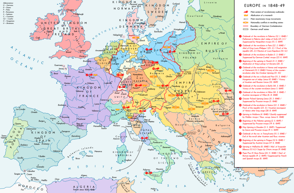
English: Europe 1848-49. Historical map with main revolutionary centres, important reactionary troop movements, states with abdications and national conflicts. Please don't alter the map, when you think there something not written or depicted correctly. Leave a message at the talk page of the file. After a verification and a possible discussion, i will upload a new map version with all new changes. This prevents an unnecessary waste of disc space and ensures a good result, aesthetically and contentwise. - The author. Deutsch: Europa 1848/49. Historische Karte mit wichtigen revolutionären Orten, Hauptschlagrichtungen konterrevolutionärer Truppen, Staaten mit Abdankungen von Monarchen und Nationalitätenkonflikten. Bitte die Karte bei Änderungs- und Korrekturwünschen nicht selbst verändern, sondern eine Anmerkung im Diskussionsbereich der Bilddatei hinterlassen. Nach einer Prüfung und ggfs. Diskussion werden evtl. Änderungen von mir zusammengefasst eingearbeitet. Das vermeidet unnötige Speicherplatz-Verschwendung und gewährleistet ein ästhetisch ansprechendes und inhaltlich korrektes Ergebnis. - Der Urheber. |
| Data | |
| Burimi |
Punë e juaja. Source of Information: Historical atlases – Ramsay Muir, George Philip (ed.): Philip's New School Atlas of Universal History, George Philip & Son, Ltd., London 1928 – Dr. Walter Leisering (ed.): Putzger Historischer Weltatlas, Cornelsen Verlag, Berlin 1992, ISBN 3-464-00176-8 – Bayerischer Schulbuch-Verlag (ed.): Großer Historischer Weltatlas, Dritter Teil, Neuzeit, Bayerischer Schulbuch-Verlag, München 1981, ISBN 3-7627-6021-7 – Prof. Dr. Vadim Oswalt u. Prof. Dr. Hans Ulrich Rudolf (ed.): Klett-Perthes Atlas zur Weltgeschichte, Ernst Klett Verlag, Stuttgart 2011, ISBN 978-3-12-828194-0 – Zentralinstitut für Geschichte der Akademie der Wissenschaften der DDR (ed.): Atlas zur Geschichte, Band 1, VEB Hermann Haack, Gotha 1989, ISBN 3-7301-0040-8 – Domokos György (ed.): Történelmi atlasz a középiskolák számára, Kartográfiai Vállalat. Budapest, Budapest 1989, ISBN 963-351-422-3 Other publications – Mike Rapport: 1848. Revolution in Europa, Wissenschaftliche Buchgesellschaft, Lizenzausgabe des Konrad Theiss Verlags, 2011, ISBN 978-3-534-23963-4 |
| Autori | Alexander Altenhof |
| Versione tjera |
|


Recompressed without quality loss with OptiPNG (1.51 MB > 1.20 MB)
Licencim
Unë, krijuesi i kësaj pune, e publikoj këtu në bazë të licensës në vijim:
This file is licensed under the Creative Commons Attribution-Share Alike 4.0 International license.
- Je i lirë të:
- ta shpërndani – ta kopjoni, rishpërndani dhe përcillni punën
- t’i bëni “remix” – të përshtatni punën
- Sipas kushteve të mëposhtme:
- atribuim – Duhet t’i jepni meritat e duhura, të siguroni një lidhje për tek licenca dhe të tregoni nëse janë bërë ndryshime. Këtë mund ta bëni në ndonjë mënyrë të arsyeshme, por jo në ndonjë mënyrë që sugjeron se licencuesi ju del zot juve apo përdorimit tuaj.
- share alike – Nëse bëni një “remix”, e shndërroni, ose ndërtoni duke u bazuar te materiali, duhet t’i shpërndani kontributet tuaja sipas të njëjtës licencë ose një të tille të përputhshme me origjinalen.
Historiku skedës
Shtypni mbi një datë/kohë për ta parë skedën siç ishte atëherë.
| Data/Koha | Miniaturë | Përmasat | Përdoruesi | Koment | |
|---|---|---|---|---|---|
| e tanishme | 15 prill 2017 01:38 | | 2.284 × 1.503 (1,22 MB) | KaterBegemot | Minor changes |
| 12 shtator 2016 00:50 |  | 2.284 × 1.503 (1,21 MB) | KaterBegemot | Changed border of Serbia | |
| 12 shtator 2016 00:34 |  | 2.284 × 1.503 (1,21 MB) | KaterBegemot | Changed color of Greece, corrected border at Tarnopol, minor text corrections | |
| 29 gusht 2016 17:17 |  | 2.284 × 1.503 (1,21 MB) | KaterBegemot | {{Information |Description ={{en|1=Europe 1848-49. Historical map with main revolutionary centres, important reactionary troop movements, states with abdications and national conflicts.<br> ''Please don't alter the map, when you think there somethin... |
Lidhje skedash
Këto faqe lidhen tek kjo skedë:
Përdorimi global i skedës
Kjo skedë përdoret nga Wiki të tjera në vijim:
- Përdorimi në ar.wikipedia.org
- Përdorimi në ast.wikipedia.org
- Përdorimi në az.wikipedia.org
- Përdorimi në el.wikipedia.org
- Përdorimi në en.wikipedia.org
- Përdorimi në he.wikipedia.org
- Përdorimi në hr.wikipedia.org
- Përdorimi në hu.wikipedia.org
- Përdorimi në it.wikipedia.org
- Përdorimi në ja.wikipedia.org
- Përdorimi në ka.wikipedia.org
- Përdorimi në km.wikipedia.org
- Përdorimi në lt.wikipedia.org
- Përdorimi në mk.wikipedia.org
- Përdorimi në pnb.wikipedia.org
- Përdorimi në ru.wikipedia.org
- Përdorimi në uk.wikipedia.org
- Përdorimi në ur.wikipedia.org
- Përdorimi në vi.wikipedia.org