Skeda:Francoprovencal-Geo-Map-1.jpg
Nuk ka përmasa më të madhaja.
Francoprovencal-Geo-Map-1.jpg ((përmasa 473 × 473 px, madhësia skedës: 211 KB, lloji MIME: image/jpeg))
| Kjo skedë është prej Wikimedia Commons dhe mund të përdoret nga projekte të tjera. Përshkrimi në këtë skedë në këtë faqe nuk është treguar më poshtë. | Shko tek faqja përshkruese në Commons |

|
Kjo linguistic map fotografi duhet duhen te behen edhe i here si nje SVG.
|


Përmbledhje
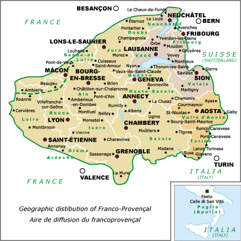
| Përshkrimi | Franco-Provençal language map showing cities & political divisions, Revision 1 | ||
| Data | |||
| Burimi | self-made, after: Tuaillon, G.(1972), "Le francoprovençal. Progrès d'une définition", in Travaux de Linguistique et de littérature X, 1, p. 337 | ||
| Autori | Charvex | ||
| Leja (Ripërdor këtë skedë) |
|
||
| Versione tjera | Replacement for Francoprovencal-Geo-Map.jpg |
Historiku skedës
Shtypni mbi një datë/kohë për ta parë skedën siç ishte atëherë.
| Data/Koha | Miniaturë | Përmasat | Përdoruesi | Koment | |
|---|---|---|---|---|---|
| e tanishme | 7 dhjetor 2007 12:32 | | 473 × 473 (211 KB) | Charvex | {{Information |Description=Franco-Provençal language map showing cities & political divisions, Revision 1 |Source=self-made |Date=7 December 2007 |Author= Charvex |Permission=Public Domain |other_versions=Replacement for Francoprovencal- |
Lidhje skedash
Këto faqe lidhen tek kjo skedë:
Përdorimi global i skedës
Kjo skedë përdoret nga Wiki të tjera në vijim:
- Përdorimi në en.wikipedia.org
- Përdorimi në frp.wikipedia.org
- Përdorimi në vec.wikipedia.org
- Përdorimi në zh.wikipedia.org