Skeda:Hochtor from Hesshütte, Ennstal Alps, Austria.jpg

Madhësia e këtij shikimi: 800 × 272 pixel. Rezolucione të tjera: 320 × 109 pixel | 640 × 217 pixel | 1.024 × 348 pixel | 1.280 × 435 pixel | 2.560 × 869 pixel | 13.340 × 4.530 pixel.
Dokument origjinal ((përmasa 13.340 × 4.530 px, madhësia skedës: 61,45 MB, lloji MIME: image/jpeg))
| Kjo skedë është prej Wikimedia Commons dhe mund të përdoret nga projekte të tjera. Përshkrimi në këtë skedë në këtë faqe nuk është treguar më poshtë. | Shko tek faqja përshkruese në Commons |
| Warning | The original file is very high-resolution. It might not load properly or could cause your browser to freeze when opened at full size. |
|---|
Përmbledhje
| Përshkrimi |
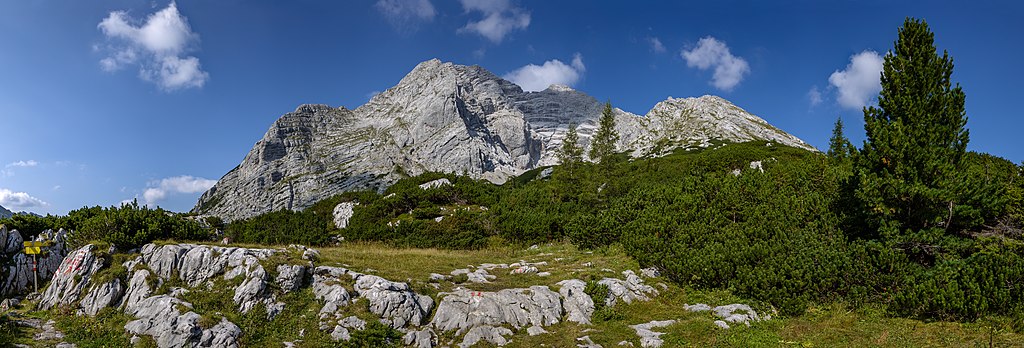
Français : Vue panoramique du mont Hochtor (2.369 m) depuis le refuge Hesshütte. Parc national de Gesäuse, Alpes d'Ennstal, Autriche
Polski: Panorama szczytu Hochtor (2369 m n.p.m.) widziana ze schroniska Hesshütte w Parku Narodowym Gesäuse w Alpach Ennstalskich, w Austrii.
Español: Vista del Hochtor (2369 m) desde Hesshütte. Parque nacional Gesäuse, Alpes de Ennstal, Austria.
Italiano: Il monte Hochtor (2 369 m s.l.m.) visto dal rifugio Hesshütte, presso il parco nazionale Gesäuse in Austria, sulle Alpi dell'Ennstal
Nederlands: De Hochtor in het Nationaal Park Gesäuse is met 2369 meter de hoogste berg van de Ennstaler Alpen in de Oostenrijkse deelstaat Stiermarken
Português: Montanha Hochtor (2369 m) vista do Hesshütte, Parque nacional Gesäuse, Alpes de Ennstal, Áustria. |
| Data | |
| Burimi | Punë e juaja |
| Autori | Michal Klajban |
| Object location | | View this and other nearby images on: OpenStreetMap |
|---|
| Camera location | | View this and other nearby images on: OpenStreetMap |
|---|

|
NOTE: This image is a panorama of Hochtor consisting of 7 frames that were merged or stitched in PtGui & Lightroom. As a result, this image necessarily underwent some form of digital manipulation. These manipulations may include blending, blurring, cloning, and colour and perspective adjustments. As a result of these adjustments, the image content may be slightly different from reality at the points where multiple images were combined. This manipulation is often required due to lens, perspective, and parallax distortions.
|
The production, editing or release of this file was supported by the Community-Budget of Wikimedia Deutschland. To see other files made with the support of Wikimedia Deutschland, please see the category Supported by Wikimedia Deutschland. |
Assessment
|
This image was selected as picture of the day on Wikimedia Commons for 23 June 2019. It was captioned as follows: Other languages:
Español: Vista del Hochtor (2369 m) desde Hesshütte. Parque nacional Gesäuse, Alpes de Ennstal, Austria. Français : Vue panoramique du mont Hochtor (2.369 m) depuis le refuge Hesshütte. Parc national de Gesäuse, Alpes d'Ennstal, Autriche. Italiano: Il monte Hochtor (2 369 m s.l.m.) visto dal rifugio Hesshütte, presso il parco nazionale Gesäuse in Austria, sulle Alpi dell'Ennstal Nederlands: De Hochtor in het Nationaal Park Gesäuse is met 2369 meter de hoogste berg van de Ennstaler Alpen in de Oostenrijkse deelstaat Stiermarken Polski: Panorama szczytu Hochtor (2369 m n.p.m.) widziana ze schroniska Hesshütte w Parku Narodowym Gesäuse w Alpach Ennstalskich, w Austrii. Português: Montanha Hochtor (2369 m) vista do Hesshütte, Parque nacional Gesäuse, Alpes de Ennstal, Áustria. |
Licencim
Unë, krijuesi i kësaj pune, e publikoj këtu në bazë të licensës në vijim:
This file is licensed under the Creative Commons Attribution-Share Alike 4.0 International license.
- Je i lirë të:
- ta shpërndani – ta kopjoni, rishpërndani dhe përcillni punën
- t’i bëni “remix” – të përshtatni punën
- Sipas kushteve të mëposhtme:
- atribuim – Duhet t’i jepni meritat e duhura, të siguroni një lidhje për tek licenca dhe të tregoni nëse janë bërë ndryshime. Këtë mund ta bëni në ndonjë mënyrë të arsyeshme, por jo në ndonjë mënyrë që sugjeron se licencuesi ju del zot juve apo përdorimit tuaj.
- share alike – Nëse bëni një “remix”, e shndërroni, ose ndërtoni duke u bazuar te materiali, duhet t’i shpërndani kontributet tuaja sipas të njëjtës licencë ose një të tille të përputhshme me origjinalen.
Historiku skedës
Shtypni mbi një datë/kohë për ta parë skedën siç ishte atëherë.
| Data/Koha | Miniaturë | Përmasat | Përdoruesi | Koment | |
|---|---|---|---|---|---|
| e tanishme | 11 shtator 2018 21:15 | 13.340 × 4.530 (61,45 MB) | Podzemnik | fix a small issue | |
| 10 shtator 2018 15:50 | 13.340 × 4.530 (61,45 MB) | Podzemnik | some spots removed | ||
| 10 shtator 2018 15:38 | 13.340 × 4.530 (61,47 MB) | Podzemnik | User created page with UploadWizard |
Lidhje skedash
Këto faqe lidhen tek kjo skedë:
Përdorimi global i skedës
Kjo skedë përdoret nga Wiki të tjera në vijim:
- Përdorimi në af.wikipedia.org
- Përdorimi në be-tarask.wikipedia.org
- Përdorimi në bn.wikipedia.org
- Përdorimi në crh.wikipedia.org
- Përdorimi në cv.wikipedia.org
- Përdorimi në fr.wikipedia.org
- Përdorimi në hu.wikipedia.org
- Përdorimi në hy.wikipedia.org
- Përdorimi në it.wiktionary.org
- Përdorimi në ka.wikipedia.org
- Përdorimi në ko.wikipedia.org
- Përdorimi në lbe.wikipedia.org
- Përdorimi në lez.wikipedia.org
- Përdorimi në mk.wikipedia.org
- Përdorimi në os.wikipedia.org
- Përdorimi në pt.wikipedia.org
- Përdorimi në ru.wikipedia.org
- Përdorimi në ru.wikinews.org
- Përdorimi në sah.wikipedia.org
- Përdorimi në tt.wikipedia.org
- Përdorimi në uk.wikipedia.org
- Përdorimi në vep.wikipedia.org
- Përdorimi në zh.wikipedia.org