Dokument origjinal((përmasa 4.709 × 9.391 px, madhësia skedës: 22,12 MB, lloji MIME: image/jpeg))

Kjo skedë është prej Wikimedia Commons dhe mund të përdoret nga projekte të tjera. Përshkrimi në këtë skedë në këtë faqe nuk është treguar më poshtë. Shko tek faqja përshkruese në Commons Shko tek faqja përshkruese në Commons

Përmbledhje

Përshkrimi
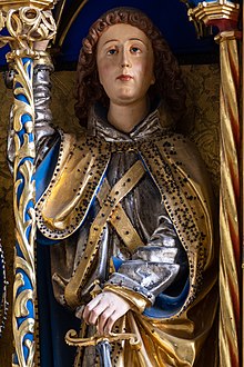
Deutsch: Hochaltar der Filialkirche Pesenbach, Gemeinde Feldkirchen an der Donau, Oberösterreich. Unbekannter Meister (genannt Meister SW), datiert 1495.
English: High altar of the subsidiary church Pesenbach, municipality of Feldkirchen an der Donau, Upper Austria. Anonymous master (called Master SW), dated 1495.
Polski: Ołtarz główny w kościele filialnym pw. św. Leonarda w miejscowości Pesenbach w gminie Feldkirchen an der Donau, w Górnej Austrii. Dzieło nieznanego mistrza (nazywanego Mistrz SW) pochodzące z 1495 roku.
  This media shows the protected monument with the number 34 in Austria. (Commons, de, Wikidata)
Čeština: Ručně vyřezávaný křídlový oltář v kostele Pesenbach v obci Feldkirchen an der Donau, Horní Rakousy od neznámého mistra z roku 1495.
Español: Altar mayor de la iglesia subsidiaria de Pesenbach, municipio de Feldkirchen an der Donau, Alta Austria. Obra creada en 1495 por un maestro anónimo conocido "Maestro SW".
Magyar: A Pesenbach leányegyház főoltára. Ismeretlen mester 1495-ben készült munkája (Feldkirchen an der Donau, Felső-Ausztria)
Македонски: Олтар на селската црква во Пезенбах, Фелдкирхен на Дунав, Горна Австрија. Непознат мајстор, 1495 г.
Nederlands: Altaar uit 1495 in de gemeente Feldkirchen an der Donau in Opper-Oostenrijk
Português: Altar-mor da igreja subsidiária de Pesenbach, município de Feldkirchen an der Donau, Alta Áustria. Obra criada em 1495 por um mestre anônimo conhecido como "Mestre SW".
Українська: Вівтар церкви Пеценбах, муніципілатет Фельдірхен ан дер Донау (Feldkirchen an der Donau), Верхня Австрія. Створена невідомим автором, датована 1495 роком.
Data
Burimi Punë e juaja
Autori Uoaei1
Camera location48° 21′ 00,72″ N, 14° 04′ 21,02″ E Kartographer map based on OpenStreetMap.View this and other nearby images on: OpenStreetMapinfo
NOTE: This image is a panorama consisting of multiple frames that were merged or stitched in software. As a result, this image necessarily underwent some form of digital manipulation. These manipulations may include blending, blurring, cloning, and colour and perspective adjustments. As a result of these adjustments, the image content may be slightly different from reality at the points where multiple images were combined. This manipulation is often required due to lens, perspective, and parallax distortions.

Boarisch | български | dansk | Deutsch | Zazaki | Ελληνικά | English | Canadian English | British English | Esperanto | español | eesti | suomi | français | hrvatski | magyar | italiano | 日本語 | 한국어 | македонски | മലയാളം | Nederlands | polski | português | русский | sicilianu | slovenščina | svenska | Türkçe | українська | العربية | 中文 | +/−

Assessment

Featured imazh
Quality imazh
Quality imazh

Wikimedia Commons

This is a featured picture on Wikimedia Commons (Fotografi të Shkëlqyeshme) and is considered one of the finest images. See its nomination here.
This is a Quality image and is considered to meet the Quality image guidelines.

If you have an image of similar quality that can be published under a suitable copyright license, be sure to upload it, tag it, and nominate it.

VI seal

This image has been assessed under the valued image criteria and is considered the most valued image on Commons within the scope: Flügelaltar Pesenbach. You can see its nomination here.

Licencim

Unë, krijuesi i kësaj pune, e publikoj këtu në bazë të licensës në vijim:
w:sq:Creative Commons
atribuim share alike
This file is licensed under the Creative Commons Attribution-Share Alike 4.0 International license.
Je i lirë të:
  • ta shpërndani – ta kopjoni, rishpërndani dhe përcillni punën
  • t’i bëni “remix” – të përshtatni punën
Sipas kushteve të mëposhtme:
  • atribuim – Duhet t’i jepni meritat e duhura, të siguroni një lidhje për tek licenca dhe të tregoni nëse janë bërë ndryshime. Këtë mund ta bëni në ndonjë mënyrë të arsyeshme, por jo në ndonjë mënyrë që sugjeron se licencuesi ju del zot juve apo përdorimit tuaj.
  • share alike – Nëse bëni një “remix”, e shndërroni, ose ndërtoni duke u bazuar te materiali, duhet t’i shpërndani kontributet tuaja sipas të njëjtës licencë ose një të tille të përputhshme me origjinalen.
WikiDaheim Diese Datei wurde im Rahmen von WikiDaheim 2017 in Österreich erstellt und hochgeladen.
Sie wurde dem Themenbereich Denkmalschutz zugeordnet.
Wikimedia Österreich
Annotations
InfoField
This image is annotated: View the annotations at Commons

Captions

Add a one-line explanation of what this file represents

16 qershor 2017

48°21'0.720"N, 14°4'21.018"E

f-number anglisht

8

focal length anglisht

33.68425267312657386849 milimetri

ISO speed anglisht

200

Historiku skedës

Shtypni mbi një datë/kohë për ta parë skedën siç ishte atëherë.

Data/KohaMiniaturëPërmasatPërdoruesiKoment
e tanishme10 gusht 2017 17:39Miniaturë për versionin duke filluar nga 10 gusht 2017 17:394.709 × 9.391 (22,12 MB)Uoaei1User created page with UploadWizard

Këto faqe lidhen tek kjo skedë:

Përdorimi global i skedës

Kjo skedë përdoret nga Wiki të tjera në vijim:

Metadata