Skeda:Pont du Gard BLS.jpg

Madhësia e këtij shikimi: 800 × 309 pixel. Rezolucione të tjera: 320 × 124 pixel | 640 × 247 pixel | 1.024 × 395 pixel | 1.280 × 494 pixel | 2.560 × 988 pixel | 12.648 × 4.882 pixel.
Dokument origjinal ((përmasa 12.648 × 4.882 px, madhësia skedës: 18,75 MB, lloji MIME: image/jpeg))
| Kjo skedë është prej Wikimedia Commons dhe mund të përdoret nga projekte të tjera. Përshkrimi në këtë skedë në këtë faqe nuk është treguar më poshtë. | Shko tek faqja përshkruese në Commons |
|
Përmbledhje
| Përshkrimi |
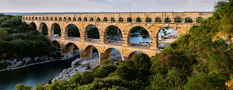
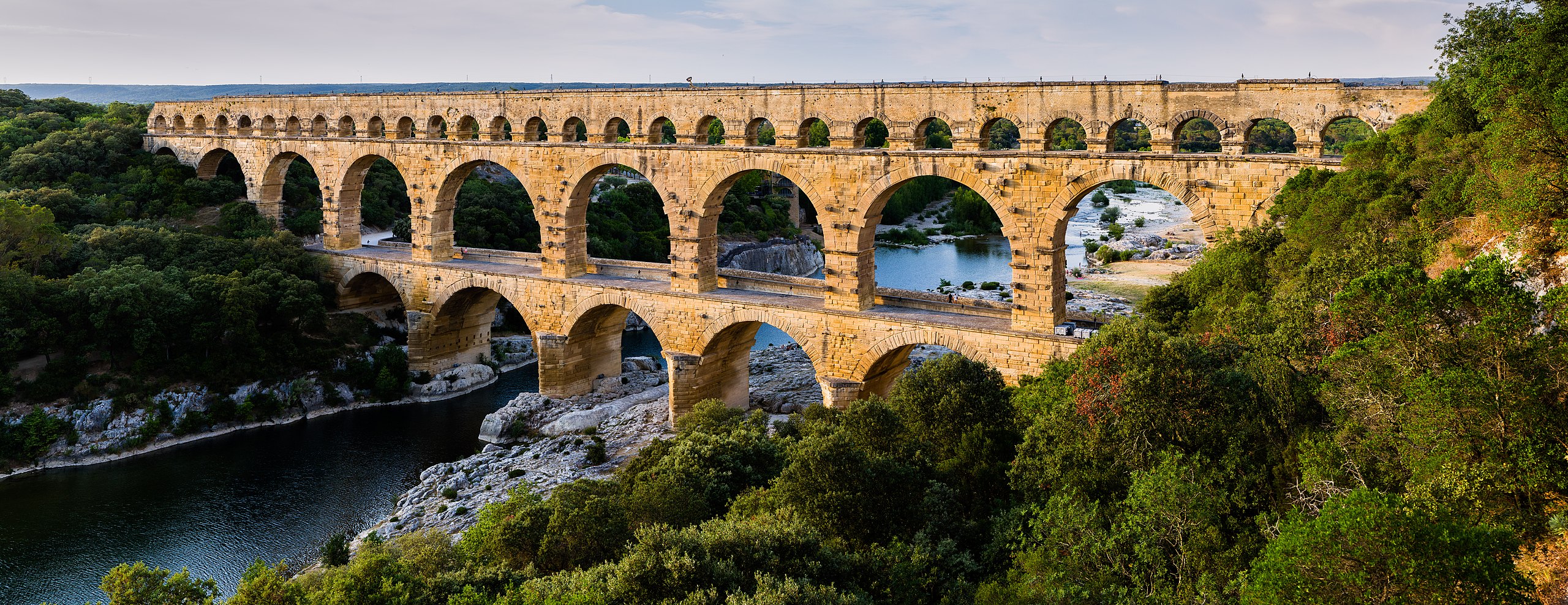
English: Pont du Gard, in Vers-Pont-du-Gard, Gard department, South France. The Pont du Gard is the most famous part of the roman aqueduct which carried water from Uzès to Nîmes until roughly the 9th century when maintenance was abandoned. The monument is 49m high and now 275m long (it was 360m when intact) at its top. It's the highest roman aqueduct, but also one of the best preserved (with the aqueduct of Segovia). The Pont du Gard has been a UNESCO world heritage site since 1985.
Français : Le Pont du Gard, à Vers-Pont-du-Gard, département du Gard, région Languedoc-Roussillon, France. Le Pont du Gard (1er siècle C.E.) est la partie la plus célèbre de l'aqueduc romain qui conduisait l'eau d'Uzès à Nîmes, jusqu'au 9ème siècle où l'on cessa de l'entretenir. Le monument fait 49 mètres de haut et aujourd'hui 275 mètres de long (360 mètres quand il était intact). C'est l'aqueduc roman le plus haut, mais aussi, avec celui de Ségovie, l'un des mieux préservés. Le Pont du Gard est un site du patrimoine mondial de l'humanité de l'UNESCO depuis 1985.
Español: El Pont du Gard (puente del Gard), en Vers-Pont-du-Gard, departamento de Gard, en la región de Languedoc-Rosellón, sur de Francia, es la parte más conocida del acueducto romano que conducía el agua desde Uzès a Nîmes hasta el siglo IX, cuando cesó su actividad. El puente mide 49 metros de alto y 275 metros de largo (360 m cuando se encontraba intacto en la antigüedad). Es el acueducto romano más alto y también, junto al de Segovia, en España, uno de los mejor conservados. El Pont du Gard fue declarado Patrimonio Mundial de la Humanidad por la UNESCO en 1985. |
| Data | |
| Burimi | Pont du Gard |
| Autori | Benh LIEU SONG (Flickr) |
| Camera location | | View this and other nearby images on: OpenStreetMap |
|---|
Licencim
Unë, krijuesi i kësaj pune, e publikoj këtu në bazë të licensës në vijim:
Kjo skedë licencohet sipas Creative Commons Attribution-Share Alike 3.0 Unported.
- Je i lirë të:
- ta shpërndani – ta kopjoni, rishpërndani dhe përcillni punën
- t’i bëni “remix” – të përshtatni punën
- Sipas kushteve të mëposhtme:
- atribuim – Duhet t’i jepni meritat e duhura, të siguroni një lidhje për tek licenca dhe të tregoni nëse janë bërë ndryshime. Këtë mund ta bëni në ndonjë mënyrë të arsyeshme, por jo në ndonjë mënyrë që sugjeron se licencuesi ju del zot juve apo përdorimit tuaj.
- share alike – Nëse bëni një “remix”, e shndërroni, ose ndërtoni duke u bazuar te materiali, duhet t’i shpërndani kontributet tuaja sipas të njëjtës licencë ose një të tille të përputhshme me origjinalen.
| Annotations | This image is annotated: View the annotations at Commons |
Historiku skedës
Shtypni mbi një datë/kohë për ta parë skedën siç ishte atëherë.
| Data/Koha | Miniaturë | Përmasat | Përdoruesi | Koment | |
|---|---|---|---|---|---|
| e tanishme | 19 qershor 2014 19:57 | 12.648 × 4.882 (18,75 MB) | Benh | Verticals. | |
| 19 qershor 2014 12:55 | 12.648 × 4.771 (18,78 MB) | Benh | User created page with UploadWizard |
Lidhje skedash
Këto faqe lidhen tek kjo skedë:
Përdorimi global i skedës
Kjo skedë përdoret nga Wiki të tjera në vijim:
- Përdorimi në af.wikipedia.org
- Përdorimi në ar.wikipedia.org
- Përdorimi në ast.wikipedia.org
- Përdorimi në ban.wikipedia.org
- Përdorimi në bg.wikipedia.org
- Përdorimi në bh.wikipedia.org
- Përdorimi në bn.wikipedia.org
- Përdorimi në bn.wikibooks.org
- Përdorimi në bxr.wikipedia.org
- Përdorimi në ca.wikipedia.org
- Përdorimi në ceb.wikipedia.org
- Përdorimi në cs.wikipedia.org
- Përdorimi në cy.wikipedia.org
- Përdorimi në da.wikipedia.org
- Përdorimi në de.wikipedia.org
- Përdorimi në de.wikivoyage.org
Shikoni më shumë përdorim global të kësaj skede.