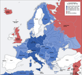
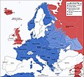
Skeda:Second world war europe 1941-1942 map en.png

Dokument origjinal((përmasa 1.090 × 1.000 px, madhësia skedës: 216 KB, lloji MIME: image/png))

Kjo skedë është prej Wikimedia Commons dhe mund të përdoret nga projekte të tjera. Përshkrimi në këtë skedë në këtë faqe nuk është treguar më poshtë. Shko tek faqja përshkruese në Commons Shko tek faqja përshkruese në Commons

Kjo military map fotografi duhet duhen te behen edhe i here si nje SVG.
Maps of the history of Europe
BCE
aC

Weichselian ice age (c. 113,000–9700) · Neolithic expansion (c. 7000–4500) · Middle Neolithic (c. 4500–4000) · Late Neolithic (c. 4000–3000) · Copper Age – Corded Ware culture (c. 2900–2350) · Copper Age – Bellbeaker culture (c. 2800–1800) · Early Bronze Age – Unetice culture (c. 2300–1600) · Late Bronze Age – Urnfield culture (c. 1300—750) · Migrations (c. 1000–100) · Hallstatt & La Tène cultures (c. 800–100) · Roman Republic (510–40) · 220 · 218 · 200 · 201–100 · 58 · 49 · 39 · 30 BCE–6 CE


CE
dC

14 · 14–37 · 60 · 60 · 69 · 80 · Migrations 100–500 · 117 · 117 · 125 · Migrations 150–774 · Economy 180 · 271 · 293–305 · 337 · 395 · c. 395 · 400 · 400 · 450 · 457–61 · 476 · 480 · Franks 481–814 · Early Slavs 500–700 · 500 · 526 · 526–600 · Christianisation to 600 · c. 550 · 650 · Pontic Steppe 650 · 665 · 800 · Vikings 800–1050 · 814 · 843–70 · 850 · 900 · 912 · 998 · 1000 · 1000 · 1054 · 1092 · First Crusade 1095–99 · 1097 · 1135 · 1142 · 1147–49 · 1190 · 1190 · 1250 · c. 1250 · 1301-1400 · 1301-1400 · 1328 · 1345 · Black Plague 1347–51 · 1360 · 1400 · Trade routes c. 1400 · 1430 · 1470 · 1490 · 1492 · 1500 · 1519 · 1550 · 1560 · Religion 1560 · Religion 1600 · Religion 1618 · 1618–48 · 1648 · 1683 · 1700 · 1701 · 1708 · 1714 · 1721 · 1725–30 · 1739–1740 · 1740 · 1748–66 · 1783–1792 · 1787 · 1787 · 1789 · 1799 · 1812 · 1812 · 1812 · 1812 · 1813 · 1815 · 1815 · 1815 · 1818 · Ottoman Empire 1830–1923 · 1848–49 · 1861 · 1867 · 1871 · 1878 · 1890 · 1905 · 1911 · 1914 · 1914 · 1919 · 1919–29 · 1923 · 1929 · 1930 · 1940 · 1941–42 · 1942–45 · Cold War 1947–91 · 1950 · 1993–2006 · 2006 to date

(this template: · view · discuss )

Përmbledhje

Annotations
InfoField
This image is annotated: View the annotations at Commons
Përshkrimi
Deutsch: Karte der vom Deutschen Reich besetzten Gebiete und der Kriegsfronten im Zweiten Weltkrieg, 1941/42.
English: A map of German front of the Second World War circa 1941-1942.
Ελληνικά: Εδαφικές κατακτήσεις του Ράιχ
Español: Conquistas territoriales del Reich
Data Original Image: 17 April 2005
Derivative Image: 22 December 2005
Burimi This file was derived from: Second world war europe 1941-1942 map de.png
Autori Original Author: User:San Jose
Derivative Author: User:ArmadniGeneral
Leja
(Ripërdor këtë skedë)
This image is a translation of the original, created and released under the terms of the GNU Free Documentation License.
Versione tjera

Derivative works of this file:  Großdeutsches Reich-europe.png [redakto]

Licencim

GNU head Ju jepet leje për ta kopjuar, shpërndarë dhe/ose ndryshuar këtë dokument sipas kushteve të Licencës GNU për Dokumentim të Lirë, versioni 1.2 ose çfarëdo versioni të mëpasshëm të botuar nga Free Software Foundation; pa Seksione të Pandryshueshme, pa Tekste Kapakësh të Përparmë, dhe pa Tekste Kapakësh të Pasmë. Një kopje e kësaj licence është përfshirë në seksionin e titulluar GNU Free Documentation License.
w:sq:Creative Commons
atribuim share alike
Kjo skedë licencohet sipas Creative Commons Attribution-Share Alike 3.0 Unported.
Je i lirë të:
  • ta shpërndani – ta kopjoni, rishpërndani dhe përcillni punën
  • t’i bëni “remix” – të përshtatni punën
Sipas kushteve të mëposhtme:
  • atribuim – Duhet t’i jepni meritat e duhura, të siguroni një lidhje për tek licenca dhe të tregoni nëse janë bërë ndryshime. Këtë mund ta bëni në ndonjë mënyrë të arsyeshme, por jo në ndonjë mënyrë që sugjeron se licencuesi ju del zot juve apo përdorimit tuaj.
  • share alike – Nëse bëni një “remix”, e shndërroni, ose ndërtoni duke u bazuar te materiali, duhet t’i shpërndani kontributet tuaja sipas të njëjtës licencë ose një të tille të përputhshme me origjinalen.
Kjo etiketë licencimi u shtua te kjo skedë si pjesë e përditësimit të lincecimit. GFDL.

Captions

Add a one-line explanation of what this file represents

Items portrayed in this file

përshkruan

Historiku skedës

Shtypni mbi një datë/kohë për ta parë skedën siç ishte atëherë.

Data/KohaMiniaturëPërmasatPërdoruesiKoment
e tanishme5 gusht 2020 18:20Miniaturë për versionin duke filluar nga 5 gusht 2020 18:201.090 × 1.000 (216 KB)Claude ZygielDistinguished statutes
28 korrik 2018 03:00Miniaturë për versionin duke filluar nga 28 korrik 2018 03:001.090 × 1.000 (184 KB)JeffyPShrinking file size
16 shkurt 2009 10:06Miniaturë për versionin duke filluar nga 16 shkurt 2009 10:061.090 × 1.000 (214 KB)Guinnog{{Information |Description=better titles |Source=*File:Second_world_war_europe_1941-1942_map_en.png |Date=2009-02-16 08:05 (UTC) |Author=*File:Second_world_war_europe_1941-1942_map_en.png: Sir Lothar *derivative work: ~~~ |Permission=see below
11 prill 2008 02:22Miniaturë për versionin duke filluar nga 11 prill 2008 02:221.090 × 1.000 (208 KB)Sir Lothar
21 dhjetor 2005 07:36Miniaturë për versionin duke filluar nga 21 dhjetor 2005 07:361.090 × 1.000 (221 KB)ArmadniGeneralA map of the Eastern front of the Second World War circa 1941-1942. The original German-language map was created by User:San Jose on 17 April 2005. It can be found here: Image:Second world war europe 1941-1942 map de.png. This image is a translat

S’ka faqe që përdorin këtë kartelë.

Përdorimi global i skedës

Kjo skedë përdoret nga Wiki të tjera në vijim:

Shikoni më shumë përdorim global të kësaj skede.

Metadata