Skeda:Tagebau Garzweiler Panorama 2005.jpg

Dokument origjinal ((përmasa 12.000 × 1.370 px, madhësia skedës: 9,62 MB, lloji MIME: image/jpeg))
| Kjo skedë është prej Wikimedia Commons dhe mund të përdoret nga projekte të tjera. Përshkrimi në këtë skedë në këtë faqe nuk është treguar më poshtë. | Shko tek faqja përshkruese në Commons |
Përmbledhje
| Përshkrimi |
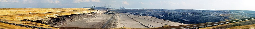
Deutsch: Panoramaaufnahme des Tagebaus Garzweiler im rheinischen Braunkohlerevier, Nordrhein-Westfalen, Deutschland
Ελληνικά: Επιφανειακό λιγνιτωρυχείο με καδοφόρους εκσκαφείς στην Γερμανία. Στα αριστερά είναι το αδιατάρακτο κοίτασμα του λιγνίτη που εξορύσσεται και στα δεξιά είναι οι σωροί απόθεσης των στείρων.
English: Panoramic view of the surface mine Garzweiler in the Rhenish lignite mining area, North Rhine-Westphalia, Germany
Español: Foto panorámica de la mina a cielo abierto de Garzweiler en la zona minera de lignito renana, Renania del Norte-Westfalia, Alemania
Français : Vue panoramique de la mine à ciel ouvert de Garzweiler dans la zone d'extraction de lignite rhénane, Rhénanie du Nord-Westphalie, Allemagne
Nederlands: Panoramische opname van de bovengrondse mijn van Garzweiler in het Rijnlandse bruinkoolgebied, Noordrijn-Westfalen, Duitsland |
|||||||||||||||||
| Data | ||||||||||||||||||
| Burimi | Punë e juaja | |||||||||||||||||
| Autori |
|
|||||||||||||||||
| Versione tjera |
|
|||||||||||||||||
| Atribuim (required by the license) | © Raimond Spekking / | |||||||||||||||||


| Camera location | | View this and other nearby images on: OpenStreetMap |
|---|
|
This image was selected as picture of the day on Wikimedia Commons for 11 February 2009. It was captioned as follows: English: Panorama of open-pit mining Garzweiler, Germany Other languages:
Afrikaans: 'n Blik oor die oopgroefmyn te Garzweiler, Duitsland English: Panorama of open-pit mining Garzweiler, Germany Español: Panorámica de la mina a cielo abierto de Garzweiler, Alemania Français : Panorama de la mine à ciel ouvert de Garzweiler, en Allemagne. Nederlands: Panorama van de bruinkoolmijn Garzweiler in de Duitse deelstaat Noord-Rijnland-Westfalen. Polski: Panoramiczne zdjęcie kopalni odkrywkowej w Garzweiler w Niemczech. Português: Panorama de uma mina a céu aberto em Garzweiler, na Alemanha Suomi: Panoraamakuva avolouhoksesta Garzweilerissä, Saksassa. Македонски: Панорама на површински коп во рудникот Гарцвајлер, Германија Русский: Панорама карьера Garzweiler (Северный Рейн-Вестфалия) Українська: Панорама гірничих виробок Garzweiler у землі Північний Рейн — Вестфалія, Німеччина, 2005. 中文: 德国加尔茨维勒露天矿坑的全景照片 中文(繁體): 德國加爾茨維勒露天礦坑的全景照片 |
Licencim
I have published this image as author under the Creative-Commons-Licence CC BY-SA 4.0.. This means that free online usage outside of Wikimedia projects under the following terms of licence is possible:
- The image is credited with "© Raimond Spekking / CC BY-SA 4.0 (via Wikimedia Commons)"
For all other kind of usages (books, journales, flyers, etc.) click on the following button. You will get all information needed.
I would be happy to receive a specimen copy or the URL of the website where the image is used.
Please write an email to raimond.spekking@gmail.com (GPG encrypted emails are welcome: Key-ID: 0xB12BE7A6), if you
- need the image in a higher resolution
- need my postal address for sending a specimen copy
- have further questions to the terms of licence
- Je i lirë të:
- ta shpërndani – ta kopjoni, rishpërndani dhe përcillni punën
- t’i bëni “remix” – të përshtatni punën
- Sipas kushteve të mëposhtme:
- atribuim – Duhet t’i jepni meritat e duhura, të siguroni një lidhje për tek licenca dhe të tregoni nëse janë bërë ndryshime. Këtë mund ta bëni në ndonjë mënyrë të arsyeshme, por jo në ndonjë mënyrë që sugjeron se licencuesi ju del zot juve apo përdorimit tuaj.
- share alike – Nëse bëni një “remix”, e shndërroni, ose ndërtoni duke u bazuar te materiali, duhet t’i shpërndani kontributet tuaja sipas të njëjtës licencë ose një të tille të përputhshme me origjinalen.
Historiku skedës
Shtypni mbi një datë/kohë për ta parë skedën siç ishte atëherë.
| Data/Koha | Miniaturë | Përmasat | Përdoruesi | Koment | |
|---|---|---|---|---|---|
| e tanishme | 6 nëntor 2007 20:54 | 12.000 × 1.370 (9,62 MB) | Raymond | completly reworked image from original photos. | |
| 5 nëntor 2007 13:25 | 12.000 × 1.464 (5,74 MB) | Raymond | de-noised | ||
| 4 maj 2007 16:07 | 12.000 × 1.464 (5,45 MB) | Raymond | non-progressive mode, sharper | ||
| 19 maj 2005 14:46 | 12.000 × 1.464 (3,49 MB) | Raymond | {{Information| |Description = Panorama of open-pit mining Garzweiler, Germany |Source = own photography |Date = 26. Mar. 2005 |Author = ~~~ - Raimond Spekking |Permission = |other_versions = }} {{GFDL-self}} Category:Mining |
Lidhje skedash
S’ka faqe që përdorin këtë kartelë.
Përdorimi global i skedës
Kjo skedë përdoret nga Wiki të tjera në vijim:
- Përdorimi në af.wikipedia.org
- Përdorimi në ar.wikipedia.org
- Përdorimi në ast.wikipedia.org
- Përdorimi në bn.wikipedia.org
- Përdorimi në ca.wikibooks.org
- Përdorimi në crh.wikipedia.org
- Përdorimi në cs.wikipedia.org
- Përdorimi në cv.wikipedia.org
- Përdorimi në da.wikipedia.org
- Përdorimi në de.wikipedia.org
- Niederrhein (Region)
- Kohle
- Bergbau
- Tagebau
- Benutzer:TomCatX
- Tagebau Garzweiler
- Benutzer:Meph666/Galerie
- Wasserburgen-Route
- Wikipedia:Kandidaten für exzellente Bilder/Archiv2005/9
- Datei:Tagebau Garzweiler Panorama 2005.jpg
- Benutzer:Artikelstube/Straße der Energie
- Rheinisches Braunkohlerevier
- Benutzer:Threedots/Portal:Bergbau
- Wikipedia:Exzellente Bilder/Landschaften
- Energiewende
- Umwelt
- Benutzer:Raymond/GAR
- Portal:Energie/Exzellente Bilder zum Thema Energie
- Wikipedia:Kandidaten für exzellente Bilder/Archiv2011/11
- Diskussion:Erneuerbare Energien/Archiv/3
- Benutzer:Andol/Landschaftsverschandelung
- Bagger 288
- Benutzer:Arne Müseler/Baustelle 5
- Përdorimi në de.wikiversity.org
- Përdorimi në el.wikipedia.org
- Përdorimi në en.wikipedia.org
Shikoni më shumë përdorim global të kësaj skede.