Skeda:Ukraine under russian occupation.svg

Size of this PNG preview of this SVG file: 800 × 538 pixel. Rezolucione të tjera: 320 × 215 pixel | 640 × 430 pixel | 1.024 × 688 pixel | 1.280 × 860 pixel | 2.560 × 1.720 pixel | 3.780 × 2.540 pixel.
Dokument origjinal (skedë SVG, fillimisht 3.780 × 2.540 pixel, madhësia e skedës: 1,85 MB)
| Kjo skedë është prej Wikimedia Commons dhe mund të përdoret nga projekte të tjera. Përshkrimi në këtë skedë në këtë faqe nuk është treguar më poshtë. | Shko tek faqja përshkruese në Commons |
Përmbledhje
| Përshkrimi |
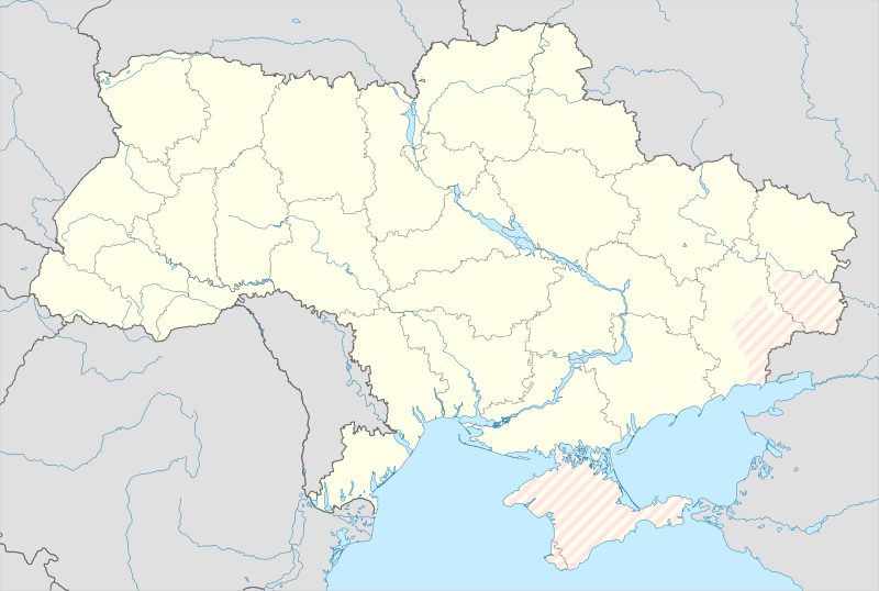
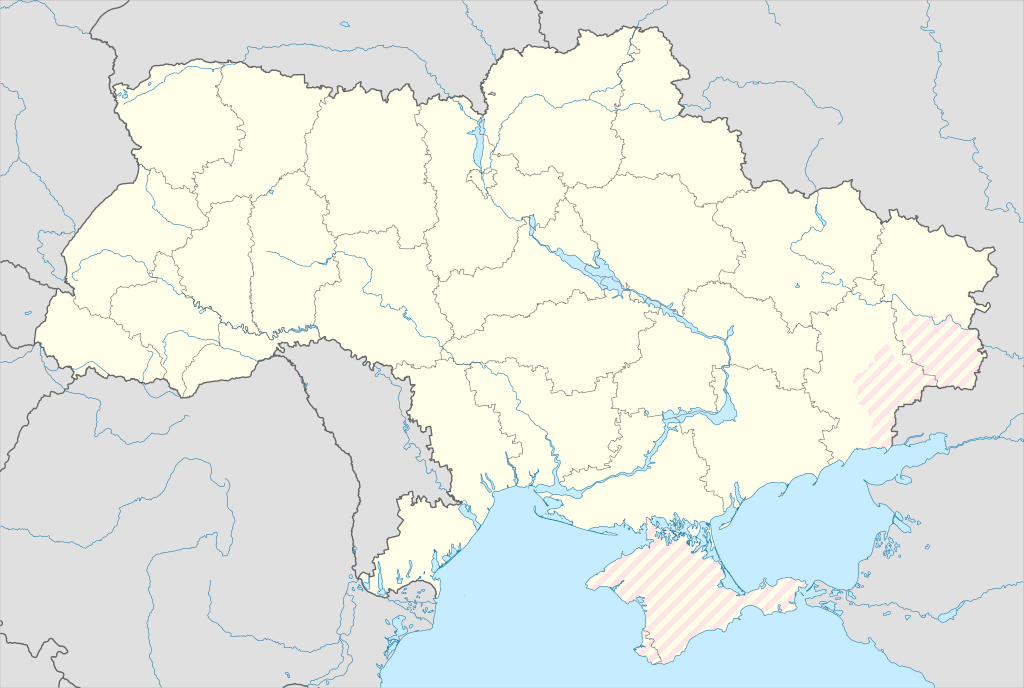
English: Location map of Ukraine under russian occupation.
Українська: Карта України з зонами російської окупації. |
| Data | |
| Burimi |
Own work using: Ukraine adm location map improved.svg, according to
|
| Autori | Yakiv Gluck |
| Versione tjera |
|
| SVG genesis | This locator map was created with Adobe Illustrator. |


Licencim
Unë, krijuesi i kësaj pune, e publikoj këtu në bazë të licensës në vijim:
This file is licensed under the Creative Commons Attribution-Share Alike 4.0 International license.
- Je i lirë të:
- ta shpërndani – ta kopjoni, rishpërndani dhe përcillni punën
- t’i bëni “remix” – të përshtatni punën
- Sipas kushteve të mëposhtme:
- atribuim – Duhet t’i jepni meritat e duhura, të siguroni një lidhje për tek licenca dhe të tregoni nëse janë bërë ndryshime. Këtë mund ta bëni në ndonjë mënyrë të arsyeshme, por jo në ndonjë mënyrë që sugjeron se licencuesi ju del zot juve apo përdorimit tuaj.
- share alike – Nëse bëni një “remix”, e shndërroni, ose ndërtoni duke u bazuar te materiali, duhet t’i shpërndani kontributet tuaja sipas të njëjtës licencë ose një të tille të përputhshme me origjinalen.
Historiku skedës
Shtypni mbi një datë/kohë për ta parë skedën siç ishte atëherë.
| Data/Koha | Miniaturë | Përmasat | Përdoruesi | Koment | |
|---|---|---|---|---|---|
| e tanishme | 17 maj 2024 04:45 | | 3.780 × 2.540 (1,85 MB) | Physeters | add detail to dnipro delta |
| 9 gusht 2023 17:45 |  | 3.780 × 2.540 (1,36 MB) | Dƶoxar | Until the war ends it has no sense to maintain another map with actual frontline | |
| 25 korrik 2023 11:32 |  | 3.780 × 2.540 (1,64 MB) | ASDFPM | Reverted to version as of 17:17, 3 October 2022 (UTC) | |
| 12 nëntor 2022 04:45 |  | 3.780 × 2.540 (1,36 MB) | Qexypnos | Reverted to version as of 17:02, 3 March 2018 (UTC) | |
| 3 tetor 2022 19:17 |  | 3.780 × 2.540 (1,64 MB) | Janitoalevic | Update | |
| 3 mars 2018 19:02 |  | 3.780 × 2.540 (1,36 MB) | Yakiv Gluck | improved using new adm loc map | |
| 27 janar 2018 03:08 |  | 1.546 × 1.038 (457 KB) | Yakiv Gluck | {{Information |Description ={{en|Location map of Ukraine under russian occupation.}} {{uk|Карта України з зонами російської окупації.}} |Source =own work, using [[:F... |
Lidhje skedash
S’ka faqe që përdorin këtë kartelë.
Përdorimi global i skedës
Kjo skedë përdoret nga Wiki të tjera në vijim:
- Përdorimi në an.wikipedia.org
- Përdorimi në de.wikipedia.org
- Përdorimi në en.wikipedia.org
- Përdorimi në es.wikipedia.org
Shikoni më shumë përdorim global të kësaj skede.