Skeda:Venezuela location map.svg

Size of this PNG preview of this SVG file: 670 × 599 pixel. Rezolucione të tjera: 268 × 240 pixel | 537 × 480 pixel | 859 × 768 pixel | 1.145 × 1.024 pixel | 2.290 × 2.048 pixel | 1.654 × 1.479 pixel.
Dokument origjinal (skedë SVG, fillimisht 1.654 × 1.479 pixel, madhësia e skedës: 743 KB)
| Kjo skedë është prej Wikimedia Commons dhe mund të përdoret nga projekte të tjera. Përshkrimi në këtë skedë në këtë faqe nuk është treguar më poshtë. | Shko tek faqja përshkruese në Commons |
Përmbledhje
| Përshkrimi |
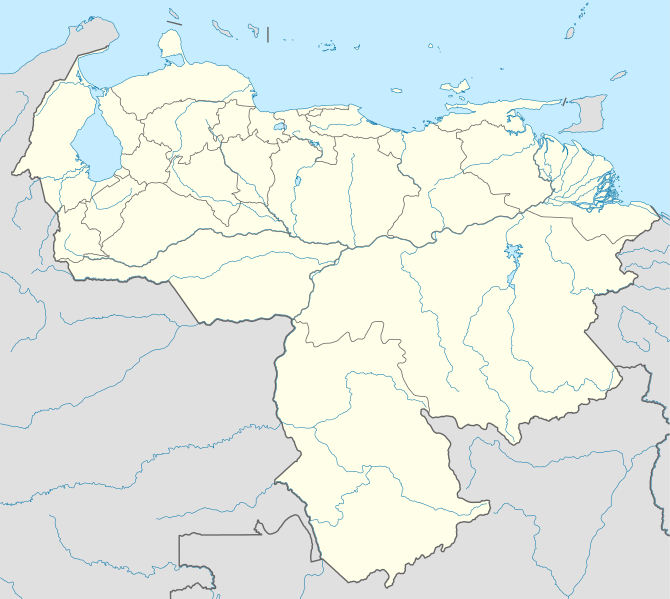
Deutsch: Positionskarte von Venezuela
Quadratische Plattkarte, N-S-Streckung 101 %. Geographische Begrenzung der Karte:
English: Location map of Venezuela
Equirectangular projection, N/S stretching 101 %. Geographic limits of the map:
|
| Data | |
| Burimi |
Punë e juaja, using
|
| Autori | NordNordWest |
| Leja (Ripërdor këtë skedë) |
Unë, krijuesi i kësaj pune, e publikoj këtu në bazë të licensës në vijim: Kjo skedë licencohet sipas Creative Commons Attribution-Share Alike 3.0 Unported.
|
| Versione tjera |
Derivative works of this file: Venezuela relief location map.jpg
|

.svg)
.jpg)

|
This map has been made or improved in the German Kartenwerkstatt (Map Lab). You can propose maps to improve as well.
|
Historiku skedës
Shtypni mbi një datë/kohë për ta parë skedën siç ishte atëherë.
| Data/Koha | Miniaturë | Përmasat | Përdoruesi | Koment | |
|---|---|---|---|---|---|
| e tanishme | 21 shtator 2009 21:38 | | 1.654 × 1.479 (743 KB) | NordNordWest | =={{int:filedesc}}== {{Information |Description= {{de|Positionskarte von Venezuela}} Quadratische Plattkarte, N-S-Streckung 101 %. Geographische Begrenzung der Karte: * N: 12.8° N * S: 0.4° N * W: 73.6° W * O: 59.6° W {{en|Location m |
Lidhje skedash
Këto faqe lidhen tek kjo skedë:
Përdorimi global i skedës
Kjo skedë përdoret nga Wiki të tjera në vijim:
- Përdorimi në af.wikipedia.org
- Përdorimi në als.wikipedia.org
- Përdorimi në am.wikipedia.org
- Përdorimi në an.wikipedia.org
- Caracas
- Maracaibo
- Valencia (Venezuela)
- Maracay
- Barquisimeto
- San Cristóbal (Venezuela)
- La Guaira
- Ciudat Bolívar
- Maturín
- Mérida (Venezuela)
- Los Teques
- Barinas (ciudat)
- Coro (Venezuela)
- San Juan de Los Morros
- La Asunción
- San Felipe (Venezuela)
- Trujillo (Venezuela)
- Puerto Ayacucho
- Cumaná
- Barcelona (Venezuela)
- Guanare
- Tucupita
- San Fernando de Apure
- San Carlos (Venezuela)
- Puerto La Cruz
- Puerto Cabello
- Ciudat Guayana
- San Fernando de Atabapo
- Ciudat Ojeda
- Cabimas
- Lechería
- Isla Ratón
- Plantilla:Mapa de localización Venezuela
- Guasdualito
- Colonia Tovar
- Urica
- Përdorimi në ast.wikipedia.org
- Përdorimi në awa.wikipedia.org
- Përdorimi në az.wikipedia.org
- Përdorimi në ba.wikipedia.org
Shikoni më shumë përdorim global të kësaj skede.