Skeda:2011-06-22 12-01-28 South Africa - Morningside.jpg

Madhësia e këtij shikimi: 800 × 531 pixel. Rezolucione të tjera: 320 × 212 pixel | 640 × 425 pixel | 1.024 × 680 pixel | 1.280 × 850 pixel | 2.560 × 1.700 pixel | 4.197 × 2.787 pixel.
Dokument origjinal ((përmasa 4.197 × 2.787 px, madhësia skedës: 6,32 MB, lloji MIME: image/jpeg))
| Kjo skedë është prej Wikimedia Commons dhe mund të përdoret nga projekte të tjera. Përshkrimi në këtë skedë në këtë faqe nuk është treguar më poshtë. | Shko tek faqja përshkruese në Commons |
Përmbledhje
| Përshkrimi |
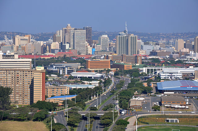
Afrikaans: Uitsig vanaf die 106m-hoë platform op die spanboog oor die Moses Mabhidastadion in Stamford Hill-voorstad, Durban. Dit verskaf hier 'n suidwaartse blik oor die M12-toegangsroete na die besigheidsdistrik van Durban-Sentraal. Die enkelkajuit SkyCar neem twee minute om op die staalspoor boontoe te ry, en dit kan op eie gewig weer na die grondstasie terugkeer in geval van 'n kragonderbreking. Die voorstad Stamford Hill beslaan die voorgrond weerskante van die M12, Durban-Sentraal lê daaragter, met Bayhead se houerhyskrane ook sigbaar, terwyl die Bluff die agtergrond vorm.
Deutsch: Blick nach Süden von der 106 Meter hohen Plattform auf dem Bogen des Moses Mabhida Stadions mit dem zentralen Geschäftsviertel von Durban, Südafrika. Die SkyCar-Einzelkabine benötigt zwei Minuten, um die Stahlschiene nach oben zu fahren, und bei einem Stromausfall kann sie mit ihrem Eigengewicht zur unteren Station hinunterfahren.
English: Southward view from the 106m high platform on the arch of the Moses Mabhida Stadium in Stamford Hill suburb, looking along the M12 route towards the business district of Durban Central, |
| Data | |
| Burimi | Punë e juaja: Hansueli Krapf (User Simisa (diskuto · kontribute)) |
| Autori |
Hansueli Krapf This file was uploaded with Commonist. |
| Leja (Ripërdor këtë skedë) |
Unë, krijuesi i kësaj pune, e publikoj këtu në bazë të licensës në vijim: Kjo skedë licencohet sipas Creative Commons Attribution-Share Alike 3.0 Unported.
|
| Camera location | | View this and other nearby images on: OpenStreetMap |
|---|
Licencim
| Annotations | This image is annotated: View the annotations at Commons |
Historiku skedës
Shtypni mbi një datë/kohë për ta parë skedën siç ishte atëherë.
| Data/Koha | Miniaturë | Përmasat | Përdoruesi | Koment | |
|---|---|---|---|---|---|
| e tanishme | 17 korrik 2011 13:29 | | 4.197 × 2.787 (6,32 MB) | Simisa |
Lidhje skedash
Këto faqe lidhen tek kjo skedë:
Përdorimi global i skedës
Kjo skedë përdoret nga Wiki të tjera në vijim:
- Përdorimi në af.wikipedia.org
- Përdorimi në am.wikipedia.org
- Përdorimi në ce.wikipedia.org
- Përdorimi në en.wikipedia.org
- Përdorimi në et.wikipedia.org
- Përdorimi në fy.wikipedia.org
- Përdorimi në he.wikipedia.org
- Përdorimi në mhr.wikipedia.org
- Përdorimi në nl.wikipedia.org
- Përdorimi në nl.wikivoyage.org
- Përdorimi në sh.wikipedia.org
- Përdorimi në sr.wikipedia.org
- Përdorimi në www.wikidata.org
- Përdorimi në zh.wikipedia.org
- Përdorimi në zu.wikipedia.org