Skeda:Iberian Peninsula in 125-en.svg

Size of this PNG preview of this SVG file: 720 × 576 pixel. Rezolucione të tjera: 300 × 240 pixel | 600 × 480 pixel | 960 × 768 pixel | 1.280 × 1.024 pixel | 2.560 × 2.048 pixel.
Dokument origjinal (skedë SVG, fillimisht 720 × 576 pixel, madhësia e skedës: 1,07 MB)
Historiku skedës
Shtypni mbi një datë/kohë për ta parë skedën siç ishte atëherë.
| Data/Koha | Miniaturë | Përmasat | Përdoruesi | Koment | |
|---|---|---|---|---|---|
| e tanishme | 29 prill 2009 11:45 |  | 720 × 576 (1,07 MB) | ArdadN | update2 |
| 29 prill 2009 11:40 |  | 720 × 576 (1,07 MB) | ArdadN | update | |
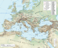
| 28 mars 2009 21:21 |  | 720 × 576 (1,07 MB) | Malus Catulus | {{Information |Description=Shows Iberian peninsula in 125 including important roads, legionnaire locations and gold/silver mines. "NOTE: Barbarian names and locations as in the works of Tacitus (written ca. 100 AD)" |Source=*[[:File:Roman_Empire_125.svg| |
Lidhje skedash
Këto faqe lidhen tek kjo skedë:
Përdorimi global i skedës
Kjo skedë përdoret nga Wiki të tjera në vijim:
- Përdorimi në arz.wikipedia.org
- Përdorimi në ast.wikipedia.org
- Përdorimi në bg.wikipedia.org
- Përdorimi në bs.wikipedia.org
- Përdorimi në el.wikipedia.org
- Përdorimi në en.wikipedia.org
- Përdorimi në es.wikipedia.org
- Përdorimi në et.wikipedia.org
- Përdorimi në eu.wikipedia.org
- Përdorimi në fi.wikipedia.org
- Përdorimi në fr.wikipedia.org
- Përdorimi në hr.wikipedia.org
- Përdorimi në hu.wikipedia.org
- Përdorimi në hy.wikipedia.org
- Përdorimi në it.wikipedia.org
- Përdorimi në ja.wikipedia.org
- Përdorimi në ko.wikipedia.org
- Përdorimi në la.wikipedia.org
- Përdorimi në lv.wikipedia.org
- Përdorimi në nl.wikipedia.org
- Përdorimi në pt.wikiversity.org
- Përdorimi në ru.wikipedia.org
- Përdorimi në sh.wikipedia.org
- Përdorimi në sl.wikipedia.org
- Përdorimi në sv.wikipedia.org
- Përdorimi në th.wikipedia.org
Shikoni më shumë përdorim global të kësaj skede.


