Skeda:Prelucrare 3D pentru La Valletta Harbour.jpg

Madhësia e këtij shikimi: 800 × 574 pixel. Rezolucione të tjera: 320 × 229 pixel | 640 × 459 pixel | 1.024 × 734 pixel | 1.280 × 918 pixel | 1.989 × 1.426 pixel.
Dokument origjinal ((përmasa 1.989 × 1.426 px, madhësia skedës: 1,49 MB, lloji MIME: image/jpeg))
| Kjo skedë është prej Wikimedia Commons dhe mund të përdoret nga projekte të tjera. Përshkrimi në këtë skedë në këtë faqe nuk është treguar më poshtë. | Shko tek faqja përshkruese në Commons |
Përmbledhje
| Përshkrimi |
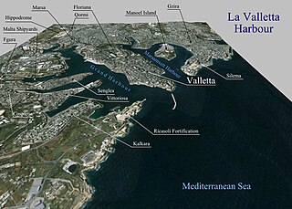
Română: Prelucrare 3D pentru La Valletta Harbour. |
| Data | |
| Burimi | Topographic data SRTM from NASA and World Imagery - NASA World Wind |
| Autori | Asybaris01 |
Licencim
| This image is in the public domain because it is a screenshot from NASA’s globe software World Wind using a public domain layer, such as Blue Marble, MODIS, Landsat, SRTM, USGS or GLOBE.
|
 |
Historiku skedës
Shtypni mbi një datë/kohë për ta parë skedën siç ishte atëherë.
| Data/Koha | Miniaturë | Përmasat | Përdoruesi | Koment | |
|---|---|---|---|---|---|
| e tanishme | 6 shtator 2011 18:52 | | 1.989 × 1.426 (1,49 MB) | Asybaris01 | {{Information |Description ={{ro|1=Prelucrare 3D pentru La Valletta Harbour.}} |Source =Topographic data SRTM from NASA and World Imagery - NASA World Wind |Author =Asybaris01 |Date =sep 2011 |Permission |
Lidhje skedash
Këto faqe lidhen tek kjo skedë:
Përdorimi global i skedës
Kjo skedë përdoret nga Wiki të tjera në vijim:
- Përdorimi në ar.wikipedia.org
- Përdorimi në be-tarask.wikipedia.org
- Përdorimi në ca.wikipedia.org
- Përdorimi në co.wikipedia.org
- Përdorimi në el.wikipedia.org
- Përdorimi në en.wikipedia.org
- Përdorimi në fa.wikipedia.org
- Përdorimi në fr.wikipedia.org
- Përdorimi në hy.wikipedia.org
- Përdorimi në it.wikipedia.org
- Përdorimi në ja.wikipedia.org
- Përdorimi në ka.wikipedia.org
- Përdorimi në mr.wikipedia.org
- Përdorimi në no.wikipedia.org
- Përdorimi në pl.wikipedia.org
- Përdorimi në ru.wikipedia.org
- Përdorimi në zh.wikipedia.org