Bischwiller
komunë në departamentin Bas-Rhin, Francë
Bischwiller ( gjermanisht: Bischweiler ; alzasisht: Bíschwiller ; shqip: Bishvileri ) [a] është aktualisht një komunë në departamentin Bas-Rhin në Grand Est në Francën verilindore, [3] vetëm në perëndim të lumit Moder .
Bischwiller
| |
|---|---|
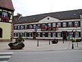
 La Laub, bashkia e dikurshme, tani muze | |
 Stema | |
Location of Bischwiller  | |
.svg) Bischwiller (Earth) | |
| Koordinatat: 48°46′00″N 7°51′27″E / 48.7667°N 7.857500°E | |
| Vendi | Franca |
| Rajoni | Grand Est |
| Departamenti | Bas-Rhin |
| Qarku | Haguenau-Wissembourg |
| Kantoni | Bischwiller |
| Ndërkomunalitet | CA Haguenau |
| Qeveria | |
| • Kryetari (2020–2026) | Jean-Lucien Netzer[1] |
| Sipërfaqja 1 | 17,25 km2 (666 sq mi) |
| Popullsia (Jan. 2019) | 12.746 |
| • Dendësia | 74/km2 (19/sq mi) |
| Zona kohore | UTC+01:00 (CET) |
| • Verës (DST) | UTC+02:00 (CEST) |
| INSEE/Kodi postar | 67046 /67240 |
| Lartësia | 123–147 m (404–482 ft) |
| 1 French Land Register data, which excludes lakes, ponds, glaciers > 1 km2 (0.386 sq mi or 247 acres) and river estuaries. | |
Gjeografia
RedaktoQyteti është 7.8 km në juglindje të Haguenaut, 8 km perëndim-veriperëndim të kufirit gjerman dhe Rajnit (Rin), dhe shtrihet 22 km veri-verilindje të Strasburgut .
Popullsia
RedaktoPër shkak të pakicës së madhe turke, Bishvileri është quajtur në mënyrë pejorative "Turcwiller" ose "Bischtanbul". [4]
| ||||||||||||||||||||||||||||||||||||||||||||||||||||||||||||||||||||||||||||||||||||||||||||||||||||||||||||||||||
Fotogaleri
Redakto-
 Farmaci e lashtë me dru
 -
 Kisha e Shën-Augustin
 -
 Bashkia e Bishvilerit
 -
 Tempull protestant: gur varri i Gjonit I, Konti Palatine i Zweibrücken (vdiq më 1604)


- ^ "Répertoire national des élus: les maires". data.gouv.fr, Plateforme ouverte des données publiques françaises (në frëngjisht). 2 dhjetor 2020.
- ^ Rapp 1823, ff. 365–366.
- ^ INSEE commune file
- ^ Gasparini, William; Koebel, Michel (2017). "Le football communautaire : enquête dans les clubs alsaciens, France". Sciences de la société. 101 (101): 144–167. doi:10.4000/sds.6469.
{{cite journal}}: Mungon ose është bosh parametri|language=(Ndihmë!)
Gabim referencash: Etiketat <ref> ekzistojnë për një grup të quajtur "lower-alpha", por nuk u gjet etiketa korresponduese <references group="lower-alpha"/>